IMAGES TAKEN NEAR TO
Harcourt Road, ALTRINCHAM, WA14 1NR
Introduction
This page details the photographs taken nearby to Harcourt Road, WA14 1NR by members of the Geograph project.
The Geograph project started in 2005 with the aim of publishing, organising and preserving representative images for every square kilometre of Great Britain, Ireland and the Isle of Man.

There are currently over 7.5m images from over14,400 individuals and you can help contribute to the project by visiting https://www.geograph.org.uk
Image Map
Images are licensed for reuse under creativecommons.org/licenses/by-sa/2.0
Notes
- Clicking on the map will re-center to the selected point.
- The higher the marker number, the further away the image location is from the centre of the postcode.
Image Listing (47 Images Found)
Images are licensed for reuse under creativecommons.org/licenses/by-sa/2.0
Image
Details
Distance
1
Roberts Building on Gladstone Road
A landmark building on the northern approach to Altrincham.
Image: © Bill Boaden
Taken: 2 May 2015
0.08 miles
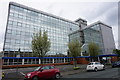
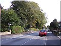
2

Roberts House
A six storey office block at the end of Gladstone Road which is largely red brick terraced and semi-detached housing
Image: © Kevin Waterhouse
Taken: 27 Feb 2023
0.08 miles
3
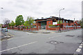
Navigation Primary School
An odd name for an inland site, especially with the school badge having a nautical theme. However the name of the locality stems from its links with the canal.
Image: © Bill Boaden
Taken: 2 May 2015
0.08 miles
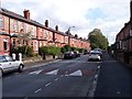
4
100 to 96 Manchester Road, Altrincham
From left to right are house numbers 100, 98 and 96 Manchester Road, in Altrincham, Greater Manchester, England. These red-brick terraced properties are atypical of much of salubrious and suburban Altrincham - which contains some of the more desirable properties in Greater Manchester - but nevertheless are a common sight along the major arterial roads in the town, and are typical of much of Trafford and Greater Manchester as a whole.
Image: © Steven Haslington
Taken: 10 May 2012
0.11 miles
5
Traffic calming on Navigation Road Altrincham
Image: © Raymond Knapman
Taken: 4 Oct 2012
0.12 miles
6
Primary school sign on Navigation Road Altrincham
Image: © Raymond Knapman
Taken: 4 Oct 2012
0.14 miles
7
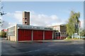
Altrincham fire station
Altrincham fire station, Princes Road, Broadheath, Altrincham, Greater Manchester
Image: © Kevin Hale
Taken: 30 Oct 2007
0.15 miles
8
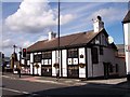
The Old Packet House on Navigation Road
Image: © Raymond Knapman
Taken: 4 Oct 2012
0.17 miles
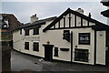
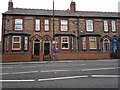
10
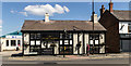
The Old Packet House
The Old Packet House public house in Altrincham.
Image: © Peter McDermott
Taken: 5 May 2017
0.17 miles