IMAGES TAKEN NEAR TO
Moss Lane, ALTRINCHAM, WA14 1BA
Introduction
This page details the photographs taken nearby to Moss Lane, WA14 1BA by members of the Geograph project.
The Geograph project started in 2005 with the aim of publishing, organising and preserving representative images for every square kilometre of Great Britain, Ireland and the Isle of Man.

There are currently over 7.5m images from over14,400 individuals and you can help contribute to the project by visiting https://www.geograph.org.uk
Image Map
Images are licensed for reuse under creativecommons.org/licenses/by-sa/2.0
Notes
- Clicking on the map will re-center to the selected point.
- The higher the marker number, the further away the image location is from the centre of the postcode.
Image Listing (505 Images Found)
Images are licensed for reuse under creativecommons.org/licenses/by-sa/2.0
Image
Details
Distance
1
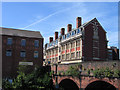
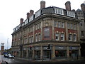
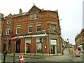
Stamford House, Altrincham
Stamford House, formerly known as Station Buildings was built adjacent to Altrincham Station in 1904-05 and is a grade II listed building. It's seen here from beside Moss Lane which crosses the railway by the bridge.
Image: © Trevor Littlewood
Taken: 14 Jul 2006
0.01 miles
2
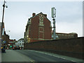
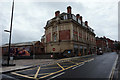
Stamford House, Altrincham - rear
The building, originally called Station Buildings, comprises offices and shops. Built 1904-5, by Charles Heathcote & Sons, it is now listed grade 2 (list entry 1084311). This is the rear view from Moss Lane. See Image for the front.
Note the railway bridge now restricted to one lane of traffic westbound with a contraflow cycle lane.
Image: © Stephen Craven
Taken: 11 Mar 2017
0.01 miles
3
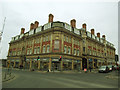
Stamford House, Altrincham - front
The building, originally called Station Buildings, comprises offices and shops. Built 1904-5, by Charles Heathcote & Sons, it is now listed grade 2 (list entry 1084311).
Image: © Stephen Craven
Taken: 11 Mar 2017
0.02 miles
4
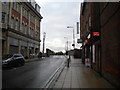
Moss Lane, Altrincham
Seen from near the junction with Stamford New Road. Moss Lane was made one way for traffic management reasons, and to enable the pavement to be widened across the bridge that carries it over the railway line immediately south of Altrincham station.
Image: © Richard Vince
Taken: 12 Sep 2015
0.02 miles
5
Stamford House, Altrincham
On the corner of Stamford New Road (left) and Moss Lane (right).
Image: © Richard Vince
Taken: 12 Sep 2015
0.02 miles
6
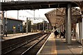
At Altrincham Station 7
At the buffers. Beyond this present termination point, the lines used to continue, beneath two bridges, to a marshalling yard which occupied the area once given over - in Victorian times - to the defunct Bowdon Station (not far from the bottom of The Downs). Latterly, the lines were ripped up and, for a number of years, the site was used as a car park before finally becoming home to up-market apartment buildings in landscaped grounds.
Image: © Anthony O'Neil
Taken: 16 Sep 2014
0.02 miles
7
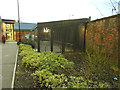
Altrincham Interchange: cycle hub
A cycle hub is more than a bicycle rack. They generally offer (paid for) secure covered parking and also servicing and hire facilities, to encourage 'bike and ride' commuting.
Image: © Stephen Craven
Taken: 11 Mar 2017
0.02 miles
9
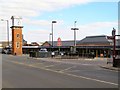
Altrincham Station
The clock tower, taxi rank and entrance to Altrincham station, on Stamford New Road.
Image: © David Dixon
Taken: 11 Mar 2010
0.02 miles
10
HSBC, Stamford New Road, Altrincham
My father worked here in the 1970s when it was the Midland Bank. I was pleased to see it is still open as a bank, although apart from the name change the interior has also changed beyond recognition from the old wooden counters with their high stools, to today's more welcoming open-plan layout.
Image: © Stephen Craven
Taken: 11 Mar 2017
0.02 miles