IMAGES TAKEN NEAR TO
Waterloo Meadow, WA13 9EJ
Introduction
This page details the photographs taken nearby to Waterloo Meadow, WA13 9EJ by members of the Geograph project.
The Geograph project started in 2005 with the aim of publishing, organising and preserving representative images for every square kilometre of Great Britain, Ireland and the Isle of Man.

There are currently over 7.5m images from over14,400 individuals and you can help contribute to the project by visiting https://www.geograph.org.uk
Image Map
Images are licensed for reuse under creativecommons.org/licenses/by-sa/2.0
Notes
- Clicking on the map will re-center to the selected point.
- The higher the marker number, the further away the image location is from the centre of the postcode.
Image Listing (12 Images Found)
Images are licensed for reuse under creativecommons.org/licenses/by-sa/2.0
Image
Details
Distance
1
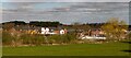
Rushgreen
New housing development at Rushgreen, Lymm.
Image: © Peter McDermott
Taken: 2 Apr 2021
0.01 miles
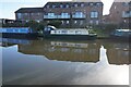
2
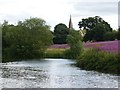
Winding hole, Bridgewater Canal, and St Peter's Oughtrington
Turning place on the Bridgewater Canal, with St Peter's Oughtrington (1871-72, by Slater and Carpenter) in the background.
Image: © Dave Dunford
Taken: 30 Jul 2015
0.13 miles
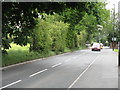
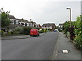
4
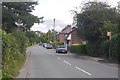
Rushgreen Road
A6411 heading for Heatley.
Image: © Richard Webb
Taken: 11 Aug 2019
0.14 miles
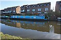
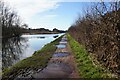
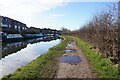
7
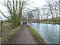
On the Towpath
Bridgewater Canal at Oughtrington
Image: © Anthony O'Neil
Taken: 22 Mar 2018
0.19 miles
10
Lymm - Bollin Drive (Through Portion)
Image: © Peter Whatley
Taken: 3 Jun 2009
0.22 miles