IMAGES TAKEN NEAR TO
Warrington Road, LYMM, WA13 9BU
Introduction
This page details the photographs taken nearby to Warrington Road, WA13 9BU by members of the Geograph project.
The Geograph project started in 2005 with the aim of publishing, organising and preserving representative images for every square kilometre of Great Britain, Ireland and the Isle of Man.

There are currently over 7.5m images from over14,400 individuals and you can help contribute to the project by visiting https://www.geograph.org.uk
Image Map
Images are licensed for reuse under creativecommons.org/licenses/by-sa/2.0
Notes
- Clicking on the map will re-center to the selected point.
- The higher the marker number, the further away the image location is from the centre of the postcode.
Image Listing (18 Images Found)
Images are licensed for reuse under creativecommons.org/licenses/by-sa/2.0
Image
Details
Distance
1
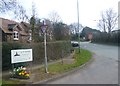
Lymm boundary sign on Warrington and Stockport Road junctions
Image: © Raymond Knapman
Taken: 19 Mar 2014
0.05 miles
5
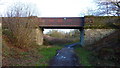
Trans Pennine Trail, Thelwall
A cast iron bridge over the former railway line, which is now the Trans Pennine Trail.
Image: © Richard Cooke
Taken: 2 Jan 2015
0.16 miles
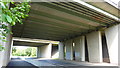
6
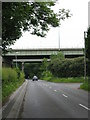
Thelwall - Warrington Road
Warrington Road is bridged by the two carriageways of the M6's Thelwall Viaducts. The original bridge with its heavy steel fabrication is the nearer of the two.
Image: © Peter Whatley
Taken: 3 Jun 2009
0.16 miles
7
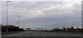
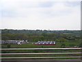
Climbing to Thelwall Viaduct
This is where the north and south carriageways part
Image: © John Firth
Taken: 12 Apr 2015
0.17 miles
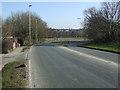
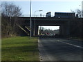
10
M6 Motorway Bridges Over A56 Near Thelwall
Image: © Richard Cooke
Taken: 10 Jun 2018
0.18 miles