IMAGES TAKEN NEAR TO
Lady Acre Close, LYMM, WA13 0SR
Introduction
This page details the photographs taken nearby to Lady Acre Close, WA13 0SR by members of the Geograph project.
The Geograph project started in 2005 with the aim of publishing, organising and preserving representative images for every square kilometre of Great Britain, Ireland and the Isle of Man.

There are currently over 7.5m images from over14,400 individuals and you can help contribute to the project by visiting https://www.geograph.org.uk
Image Map
Images are licensed for reuse under creativecommons.org/licenses/by-sa/2.0
Notes
- Clicking on the map will re-center to the selected point.
- The higher the marker number, the further away the image location is from the centre of the postcode.
Image Listing (17 Images Found)
Images are licensed for reuse under creativecommons.org/licenses/by-sa/2.0
Image
Details
Distance
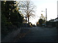
4
Path between Huntsfield Close and Lakeside Road, Lymm
Image: © Gary Rogers
Taken: 14 Apr 2016
0.14 miles
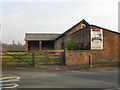
5
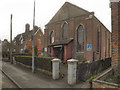
Sion Independent Methodist Church
The Sion Independent Methodist Church on Cherry Lane.
Image: © David Dixon
Taken: 22 Mar 2012
0.15 miles
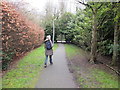
6
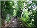
Lymm Dam footpath
The lower of at least two paths along the western side of Lymm Dam.
Image: © Dave Dunford
Taken: 30 Jul 2015
0.16 miles
7
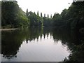
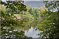
Lymm Dam
This picture was taken from SJ679866 looking south down the length of the lake.
Image: © Dave Smethurst
Taken: 3 Sep 2005
0.17 miles
8
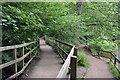
Boardwalk and lakeside path at Lymm Dam
The lake is to the right here and above and out of sight is Lakeside Road.
Image: © Trevor Harris
Taken: 1 Aug 2021
0.18 miles
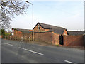
10
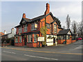
The Crown
The Crown public house on Booth's Hill Road (A56), Lymm.
Image: © David Dixon
Taken: 22 Mar 2012
0.21 miles