IMAGES TAKEN NEAR TO
Eagle Brow, LYMM, WA13 0LP
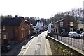
Introduction
This page details the photographs taken nearby to Eagle Brow, WA13 0LP by members of the Geograph project.
The Geograph project started in 2005 with the aim of publishing, organising and preserving representative images for every square kilometre of Great Britain, Ireland and the Isle of Man.

There are currently over 7.5m images from over14,400 individuals and you can help contribute to the project by visiting https://www.geograph.org.uk
Image Map
Images are licensed for reuse under creativecommons.org/licenses/by-sa/2.0
Notes
- Clicking on the map will re-center to the selected point.
- The higher the marker number, the further away the image location is from the centre of the postcode.
Image Listing (133 Images Found)
Images are licensed for reuse under creativecommons.org/licenses/by-sa/2.0
Image
Details
Distance
1
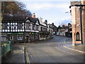
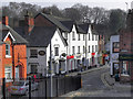
The Spread Eagle
Looking up Eagle Brow, 'The Spread Eagle' pub is on the left.
Image: © David Newton
Taken: 20 Nov 2009
0.00 miles
2
Spread Eagle, Lymm
From the bridge over the Sow Brook
Image: © Dave Dunford
Taken: 30 Jul 2015
0.01 miles
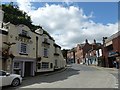
4
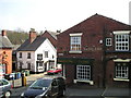
Lymm village centre
Central Lymm, at the junction of Eagle Brow and The Dingle, in Cheshire, England.
Image: © Steven Haslington
Taken: 27 Apr 2013
0.02 miles
5
The Saddlers Arms Pub, Lymm
Bridgewater Street LYMM WA13 0AB close to The Bridgewater Canal
Image: © canalandriversidepubs co uk
Taken: 12 Apr 2010
0.03 miles
6
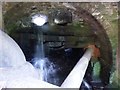
Sow Brook tunnel
Complicated triple channel of the Sow Brook passing under the A56 in the centre of Lymm.
Image: © Dave Dunford
Taken: 30 Jul 2015
0.03 miles
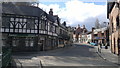
7
Lymm
Bridgewater Street, from the towpath on the Bridgewater Canal at Lymm.
Image: © David Dixon
Taken: 22 Mar 2012
0.03 miles
8
Business premises, Henry Street, Lymm
On the south bank of the Bridgewater Canal.
Image: © Christine Johnstone
Taken: 30 May 2021
0.03 miles
9
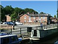
Boat Stage in Lymm
Viewed from the aqueduct on the Bridgewater Canal
Image: © Raymond Knapman
Taken: 19 Mar 2014
0.03 miles
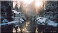
10

The Dingle at Lymnn
Also known as the Lower Dam. The wooden path leads up to the Top Dam.
Image: © Mark
Taken: 2 Jun 2013
0.04 miles