IMAGES TAKEN NEAR TO
Ridgway Gardens, LYMM, WA13 0HQ
Introduction
This page details the photographs taken nearby to Ridgway Gardens, WA13 0HQ by members of the Geograph project.
The Geograph project started in 2005 with the aim of publishing, organising and preserving representative images for every square kilometre of Great Britain, Ireland and the Isle of Man.

There are currently over 7.5m images from over14,400 individuals and you can help contribute to the project by visiting https://www.geograph.org.uk
Image Map
Images are licensed for reuse under creativecommons.org/licenses/by-sa/2.0
Notes
- Clicking on the map will re-center to the selected point.
- The higher the marker number, the further away the image location is from the centre of the postcode.
Image Listing (27 Images Found)
Images are licensed for reuse under creativecommons.org/licenses/by-sa/2.0
Image
Details
Distance
1
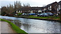
Bridgewater Canal, Lymm
Car parking to Ridgeway Gardens on the south side of the canal.
Image: © Richard Cooke
Taken: 30 Dec 2012
0.03 miles
3
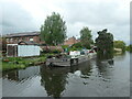
Bridgewater Canal, east of Barsbank Aqueduct, Lymm
The canal company's Work Float No 1 is moored on the south bank.
Image: © Christine Johnstone
Taken: 22 May 2021
0.08 miles
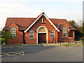
4

St. Winefrides Church
A modern Catholic church.
Image: © Mike Stace
Taken: 19 Oct 2008
0.08 miles
5
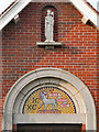
St Winefride's Church (detail)
Detail over the doorway of Image
Image: © David Dixon
Taken: 22 Mar 2012
0.10 miles
6
St Winefride's Catholic Church
St Winefride's Catholic Church on Booth's Hill Road, Lymm.
Image: © David Dixon
Taken: 22 Mar 2012
0.10 miles
7
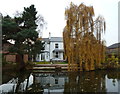
Waterside house on Bridgewater Canal, Lymm
Image: © Anthony O'Neil
Taken: 16 Nov 2012
0.11 miles
8
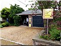
10 Statham Avenue
This house has opened its garden in support of National Gardens Scheme www.ngs.org.uk
Image: © Norman Caesar
Taken: 14 Jun 2015
0.12 miles
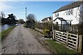
10
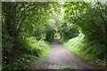
Trans Pennine Trail, Lymm
Closed to passengers in 1962, the railway continued as a freight line until 1985. Now a rails to trails conversion giving a traffic free route between Warrington and Altrincham.
The closure was probably precipitated by the need to renovate the Latchford Viaduct. At that time one of the Stupid's big ideas was an ideological loathing of railways. Even the Forth Bridge (same engineers, Arrols) was considered for closure.
Image: © Richard Webb
Taken: 11 Aug 2019
0.13 miles