IMAGES TAKEN NEAR TO
Crouchley Hall Mews, Crouchley Lane, LYMM, WA13 0BX
Introduction
This page details the photographs taken nearby to Crouchley Hall Mews, Crouchley Lane, WA13 0BX by members of the Geograph project.
The Geograph project started in 2005 with the aim of publishing, organising and preserving representative images for every square kilometre of Great Britain, Ireland and the Isle of Man.

There are currently over 7.5m images from over14,400 individuals and you can help contribute to the project by visiting https://www.geograph.org.uk
Image Map
Images are licensed for reuse under creativecommons.org/licenses/by-sa/2.0
Notes
- Clicking on the map will re-center to the selected point.
- The higher the marker number, the further away the image location is from the centre of the postcode.
Image Listing (5 Images Found)
Images are licensed for reuse under creativecommons.org/licenses/by-sa/2.0
Image
Details
Distance
1
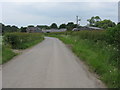
Crouchley Hall Farm
New residential conversions by the side of a public footpath.
Image: © michael ely
Taken: 8 May 2014
0.01 miles
2
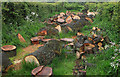
Blocked footpath
Near Crouchley Hall Farm,Lymm.
Image: © michael ely
Taken: 8 May 2014
0.05 miles
3
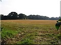
farmland
This image taken from SJ-68549-86327 looking SW shows the field having recently been harvested.
Image: © Dave Smethurst
Taken: 3 Sep 2005
0.08 miles
4
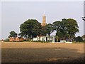
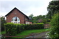
Water Tower
This building caught my eye as we walked down Crouchley lane. I couldn't quite work out if the old stone tower was behind or if the new had been built into the old tower. It is marked as Wr Twr on the OS map looking this up when I got home it is the abbreviation for Water Tower.
Image: © Dave Smethurst
Taken: 3 Sep 2005
0.19 miles