IMAGES TAKEN NEAR TO
Prince Henry Square, WARRINGTON, WA1 2QH
Introduction
This page details the photographs taken nearby to Prince Henry Square, WA1 2QH by members of the Geograph project.
The Geograph project started in 2005 with the aim of publishing, organising and preserving representative images for every square kilometre of Great Britain, Ireland and the Isle of Man.

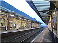
There are currently over 7.5m images from over14,400 individuals and you can help contribute to the project by visiting https://www.geograph.org.uk
Image Map
Images are licensed for reuse under creativecommons.org/licenses/by-sa/2.0
Notes
- Clicking on the map will re-center to the selected point.
- The higher the marker number, the further away the image location is from the centre of the postcode.
Image Listing (214 Images Found)
Images are licensed for reuse under creativecommons.org/licenses/by-sa/2.0
Image
Details
Distance
1
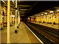
Station Architecture
The night-time lighting really helps to pick out the sweeping curves in the brickwork along the walls, and the cast iron pillars that support the roof.
At the far end of the southern platform is the signal box. The station was opened in 1873 by the Cheshire Lines Committee.
Image: © Matthew Hatton
Taken: 4 Oct 2010
0.05 miles
2
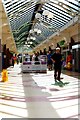
Cockhedge Centre, Warrington
The Cockhedge Centre is, predominantly, home to Asda but it is also home to a number of 'pound shops', vape stands, mobile phone accessory stalls and charity shops. It is impossible to pass through it without running the gauntlet of myriad 'chuggers' and Sky reps.
Image: © Matt Harrop
Taken: 14 Jul 2016
0.05 miles

4
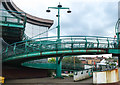
Spiral footbridge, Cockhedge Centre, Warrington
Opened in 1984, The Cockhedge Shopping Centre was constructed by Williams Tarr for Charterhall Properties.
Some of the interesting features include cast iron framed colonnades to reflect the architectural style of the Cockhedge Spinning Mill that formerly stood on the site, and an arched timber pedestrian link bridge over Scotland Road. This is linked to the Centre by a green spiral footbridge (which this photographer notes nervously, moves alarmingly in a mild breeze).
Image: © Matt Harrop
Taken: 5 Aug 2016
0.06 miles
5
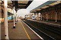
Warrington Central Station
Looking east.
Image: © Richard Sutcliffe
Taken: 13 Feb 2016
0.06 miles
6
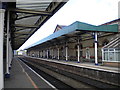
Warrington Central station
The building and canopy on the up (eastbound, towards Manchester) platform, seen from the down platform. The building and the canopy supports look very well cared for, so it is unfortunate that the canopy itself is not very photogenic.
Image: © Richard Vince
Taken: 28 Jul 2012
0.07 miles
7
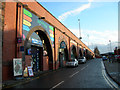
Crown Street Arches
A large variety of retail outlets have occupied the arches in Crown Street under the Midland Expressway bypassing Warrington Town Centre
Image: © Mike Lyne
Taken: 26 Jan 2012
0.07 miles
8
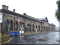
Warrington Central station frontage
Warrington Central is one of two railway stations serving the town of Warrington. Central is on a railway line running east-west through the town, linking Manchester with Liverpool, while the other station (Bank Quay) is on the West Coast Main Line which runs north-south.
This building is original station entrance and ticket office. It is now converted into business units which are rented, while the station entrance and booking office are in a new building with direct access to the passing street - see this image Image
Image: © Malc McDonald
Taken: 8 Oct 2011
0.07 miles
9
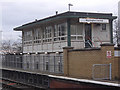
Signal box, Warrington Central
Located at the eastern end of platform two.
Image: © michael ely
Taken: 16 Dec 2008
0.07 miles