IMAGES TAKEN NEAR TO
Academy Street, WARRINGTON, WA1 2BQ
Introduction
This page details the photographs taken nearby to Academy Street, WA1 2BQ by members of the Geograph project.
The Geograph project started in 2005 with the aim of publishing, organising and preserving representative images for every square kilometre of Great Britain, Ireland and the Isle of Man.

There are currently over 7.5m images from over14,400 individuals and you can help contribute to the project by visiting https://www.geograph.org.uk
Image Map
Images are licensed for reuse under creativecommons.org/licenses/by-sa/2.0
Notes
- Clicking on the map will re-center to the selected point.
- The higher the marker number, the further away the image location is from the centre of the postcode.
Image Listing (182 Images Found)
Images are licensed for reuse under creativecommons.org/licenses/by-sa/2.0
Image
Details
Distance
1
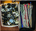
Pins and Needles
An unexpected visual pun appears while rummaging for treasure in the Salvation Army charity shop on Academy Way in Warrington
Image: © Matt Harrop
Taken: 21 Oct 2016
0.02 miles
2
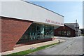
Salvation Army Church, Warrington
A very modern church design on Academy Way, Warrington, with a tiny Salvation Army charity shop nestling behind it.
Image: © Matt Harrop
Taken: 17 Aug 2016
0.02 miles
4
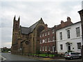
St Mary and Buttermarket Street
The Roman Catholic church of St Mary in Buttermarket Street was the last church to be designed by E.W. Pugin before his early death in 1875 at the age of 40. The church was opened in 1877. Buttermarket Street contains several attractive Georgian buildings and in 1972 was designated a conservation area.
Image: © Sue Adair
Taken: 22 Jul 2007
0.06 miles
5
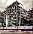
Warrington
New development in Warrington town centre.
Image: © Peter McDermott
Taken: 18 Aug 2018
0.08 miles
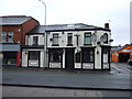
6
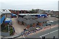
Time Square, Warrington awaits demolition
The first building to be built on the Time Square site will be fitted out to serve as a two-year provisional home for the market to allow the existing, outdated market hall to be demolished and the new market hall to be constructed on the site of the former Boots Building on Bridge Street.
Image: © Matt Harrop
Taken: 13 Apr 2015
0.08 miles
7

Wired
Night club on Mersey Street. Warrington used to be a centre for the steel industry, particularly wire.
Image: © Eirian Evans
Taken: 14 May 2009
0.08 miles
8
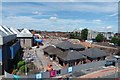
Demolition of Time Square, Warrington June 2015
An update on the massive regeneration project in Warrington's Town Centre shows the majority of the Time Square retail area flattened while the pub/restaurant Time Square/Baffitos has its tiles removed prior to demolition.
Image: © Matt Harrop
Taken: 3 Jun 2015
0.09 miles
9
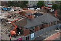
Demolition of Time Square, Warrington June 2015 - Clock is removed
One of the four mildly iconic clocks from the tower of the former Time Square bar/restaurant is carefully removed prior to its demolition.
Image: © Matt Harrop
Taken: 9 Jun 2015
0.09 miles
10
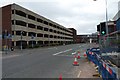
Academy Way multi-storey car park, Warrington
Awaiting demolition as part of Warrington's major redevelopment, the Academy Way car park serves the Market primarily, via a footbridge of extraordinary ugliness.
Image: © Matt Harrop
Taken: 12 Apr 2015
0.09 miles