IMAGES TAKEN NEAR TO
Crow Lane West, NEWTON-LE-WILLOWS, WA12 9YS
Introduction
This page details the photographs taken nearby to Crow Lane West, WA12 9YS by members of the Geograph project.
The Geograph project started in 2005 with the aim of publishing, organising and preserving representative images for every square kilometre of Great Britain, Ireland and the Isle of Man.

There are currently over 7.5m images from over14,400 individuals and you can help contribute to the project by visiting https://www.geograph.org.uk
Image Map
Images are licensed for reuse under creativecommons.org/licenses/by-sa/2.0
Notes
- Clicking on the map will re-center to the selected point.
- The higher the marker number, the further away the image location is from the centre of the postcode.
Image Listing (8 Images Found)
Images are licensed for reuse under creativecommons.org/licenses/by-sa/2.0
Image
Details
Distance
3
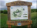
Lyme and Wood Pits Country Park, sign
Image: © Alex McGregor
Taken: 12 Jun 2013
0.15 miles
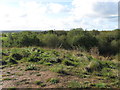
7
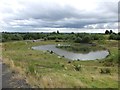
Fishing Pond at Lyme and Wood Pits Colliery Site
West of Vista Road, Haydock
Image: © Gary Rogers
Taken: 21 Aug 2016
0.24 miles
8
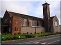
St. Patrick's R.C. Church, Common Road, Earlestown
This Church was erected in 1958 to replace the previous one erected in 1930.
Image: © Michael Heavey
Taken: 6 May 2007
0.25 miles