IMAGES TAKEN NEAR TO
Sunnybank Close, NEWTON-LE-WILLOWS, WA12 9JD
Introduction
This page details the photographs taken nearby to Sunnybank Close, WA12 9JD by members of the Geograph project.
The Geograph project started in 2005 with the aim of publishing, organising and preserving representative images for every square kilometre of Great Britain, Ireland and the Isle of Man.

There are currently over 7.5m images from over14,400 individuals and you can help contribute to the project by visiting https://www.geograph.org.uk
Image Map
Images are licensed for reuse under creativecommons.org/licenses/by-sa/2.0
Notes
- Clicking on the map will re-center to the selected point.
- The higher the marker number, the further away the image location is from the centre of the postcode.
Image Listing (17 Images Found)
Images are licensed for reuse under creativecommons.org/licenses/by-sa/2.0
Image
Details
Distance
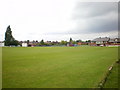
4
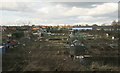
Allotments, Newton-Le-Willows
Viewed from the train.
Image: © Richard Sutcliffe
Taken: 14 Feb 2016
0.16 miles
5
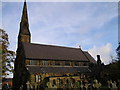
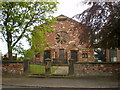
The R.C. Church of Saints Mary and John, Newton le Willows
This is a listed building.
Image: © Michael Heavey
Taken: Unknown
0.17 miles
6
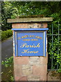
St Mary's & St John's Catholic Church, Sign
Image: © Alexander P Kapp
Taken: 19 May 2009
0.17 miles
7
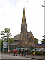
St Mary's & St John's Catholic Church
Image: © Alexander P Kapp
Taken: 19 May 2009
0.18 miles
8
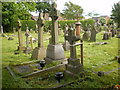
St Mary's & St John's Catholic Church, Graveyard
Image: © Alexander P Kapp
Taken: 19 May 2009
0.18 miles
9
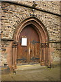
St Mary's & St John's Catholic Church, Doorway
Image: © Alexander P Kapp
Taken: 19 May 2009
0.18 miles