IMAGES TAKEN NEAR TO
Conroy Way, NEWTON-LE-WILLOWS, WA12 8SR
Introduction
This page details the photographs taken nearby to Conroy Way, WA12 8SR by members of the Geograph project.
The Geograph project started in 2005 with the aim of publishing, organising and preserving representative images for every square kilometre of Great Britain, Ireland and the Isle of Man.

There are currently over 7.5m images from over14,400 individuals and you can help contribute to the project by visiting https://www.geograph.org.uk
Image Map
Images are licensed for reuse under creativecommons.org/licenses/by-sa/2.0
Notes
- Clicking on the map will re-center to the selected point.
- The higher the marker number, the further away the image location is from the centre of the postcode.
Image Listing (34 Images Found)
Images are licensed for reuse under creativecommons.org/licenses/by-sa/2.0
Image
Details
Distance
1
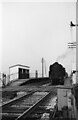
Waiting for signals, Vulcan Halt ? 1966
The station was a very basic structure, built to serve the adjacent Vulcan Foundry engineering works. It had closed to passengers the previous year. The line was the original Warrington an Newton Railway, built in 1831 as a branch off the Liverpool and Manchester Railway, and in 1837 becoming part of the Grand Junction Railway to Birmingham.
The locomotive is 92116, a British Railways Standard Class 9 2-10-0 on a freight train.
Image: © Alan Murray-Rust
Taken: 23 Feb 1966
0.06 miles
2
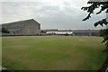
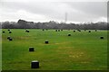
Vulcan Works
Just a snippet of the vast Vulcan Works near Earlestown. The expanse of grass in the foreground is a bowling green.
Image: © andy
Taken: 27 Jul 2005
0.08 miles
5
What was the Vulcan Works, Earlestown
Link to a short history of the works http://www.n-le-w.co.uk/index.php?option=com_content&task=view&id=37&Itemid=27
Image: © Alexander P Kapp
Taken: 19 May 2009
0.12 miles
7
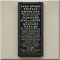
Take Notice: Private Property
It is thought that the construction of Vulcan Village began in 1833, though records of the origin of the Village are few and fragmented. The only indication that the Village existed in 1835, are the notices to hawkers and ballad singers, which are located on the gable ends of Derby Row in the Village Dated 1st of May 1835, the notice was probably the result of harassment by hawkers and others in a similar plight, which was a common occurrence in the years following the Napoleonic Wars. This notice is on the northern end of the row, there is an identical notice on the southern end.
TAKE NOTICE
PRIVATE
PROPERTY
WE DO HEREBY
CAUTION ALL
HAWKERS
RAG AND BONE
DEALERS
BEGGARS
BALLAD
SINGERS &c FROM
TRESPASSING ON
THESE PREMISES
ANY PERSON OR
PERSONS OF THE
ABOVE DESCRIPTION
FOUND HEREON
AFTER THIS NOTICE
WILL BE
PROSECUTED
WITH THE UTMOST
RIGOR OF THE
LAW
VULCAN FOUNDRY
MAY 1st 1835.
Image: © David Dixon
Taken: 28 Jan 2013
0.13 miles
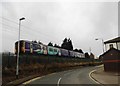
8
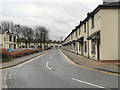
Vulcan Village, Derby Row
The Vulcan Village Conservation Area has 114 properties. With the exception of two, all the buildings are modest two storey domestic dwellings of 19th Century origin and style. All of the residential properties are in six rows of terraces (Manchester, Liverpool, Derby, Sheffield, Chester and London Row) with narrow frontages directly onto the footways.
This is Wargrave Road, looking south through the village; on the right hand side is Derby Row. To the left is The Vulcan Inn.
Image: © David Dixon
Taken: 28 Jan 2013
0.13 miles
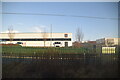
9
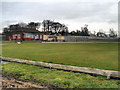
The Vulcan Bowling Club
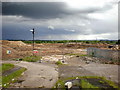
The Vulcan Works (operated by MAN B&W Diesel since 2000) closed at the end of 2002 and the business transferred to the MAN B&W Diesel Ltd, Mirrlees Blackstone
site at Stockport. The Vulcan Foundry was finally demolished in 2006 and the site was levelled to give way to a proposed urban village.
The bowling green at the north west corner of the site is all that remains.
Image: © David Dixon
Taken: 28 Jan 2013
0.14 miles
10
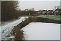
The infilled Hey Lock on the Sankey Canal
Image: © David Long
Taken: 8 Feb 2007
0.14 miles