IMAGES TAKEN NEAR TO
Ingham Avenue, NEWTON-LE-WILLOWS, WA12 8SG
Introduction
This page details the photographs taken nearby to Ingham Avenue, WA12 8SG by members of the Geograph project.
The Geograph project started in 2005 with the aim of publishing, organising and preserving representative images for every square kilometre of Great Britain, Ireland and the Isle of Man.

There are currently over 7.5m images from over14,400 individuals and you can help contribute to the project by visiting https://www.geograph.org.uk
Image Map
Images are licensed for reuse under creativecommons.org/licenses/by-sa/2.0
Notes
- Clicking on the map will re-center to the selected point.
- The higher the marker number, the further away the image location is from the centre of the postcode.
Image Listing (46 Images Found)
Images are licensed for reuse under creativecommons.org/licenses/by-sa/2.0
Image
Details
Distance
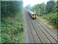
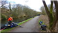
3
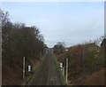
Railway heading north
Towards Newton le Willows.
Image: © JThomas
Taken: 16 Feb 2013
0.07 miles
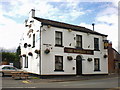
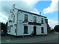
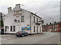
10
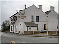
The Wargrave Inn
Public house on Wargrave Road, between Wargrave and Vulcan Village.
Image: © David Dixon
Taken: 28 Jan 2013
0.13 miles