IMAGES TAKEN NEAR TO
Alder Street, NEWTON-LE-WILLOWS, WA12 8HS
Introduction
This page details the photographs taken nearby to Alder Street, WA12 8HS by members of the Geograph project.
The Geograph project started in 2005 with the aim of publishing, organising and preserving representative images for every square kilometre of Great Britain, Ireland and the Isle of Man.

There are currently over 7.5m images from over14,400 individuals and you can help contribute to the project by visiting https://www.geograph.org.uk
Image Map
Images are licensed for reuse under creativecommons.org/licenses/by-sa/2.0
Notes
- Clicking on the map will re-center to the selected point.
- The higher the marker number, the further away the image location is from the centre of the postcode.
Image Listing (14 Images Found)
Images are licensed for reuse under creativecommons.org/licenses/by-sa/2.0
Image
Details
Distance
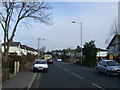
3
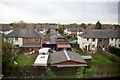
Acorn Street and Poplar Avenue, Newton-le-Willows
As seen from the railway.
Image: © Mike Pennington
Taken: 12 Nov 2015
0.10 miles
4
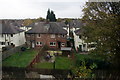
Houses in Acorn Street, Newton-le-Willows
As seen from the railway.
Image: © Mike Pennington
Taken: 12 Nov 2015
0.12 miles
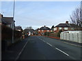
5
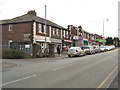
Shops on Park Road South
Park Road South at Wargrave.
Image: © David Dixon
Taken: 28 Jan 2013
0.18 miles
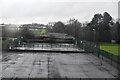
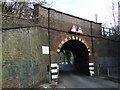
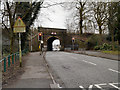
8
The railway bridge over Park Road North
Image: © Steve Daniels
Taken: 15 Sep 2011
0.21 miles