IMAGES TAKEN NEAR TO
Sankey Valley Industrial Estate, Junction Lane, NEWTON-LE-WILLOWS, WA12 8DN
Introduction
This page details the photographs taken nearby to Sankey Valley Industrial Estate, Junction Lane, WA12 8DN by members of the Geograph project.
The Geograph project started in 2005 with the aim of publishing, organising and preserving representative images for every square kilometre of Great Britain, Ireland and the Isle of Man.

There are currently over 7.5m images from over14,400 individuals and you can help contribute to the project by visiting https://www.geograph.org.uk
Image Map
Images are licensed for reuse under creativecommons.org/licenses/by-sa/2.0
Notes
- Clicking on the map will re-center to the selected point.
- The higher the marker number, the further away the image location is from the centre of the postcode.
Image Listing (35 Images Found)
Images are licensed for reuse under creativecommons.org/licenses/by-sa/2.0
Image
Details
Distance
1
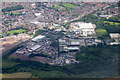
Sankey Valley Industrial Estate, Newton-le-Willows, from the air
Taken from a plane on approach to Liverpool John Lennon Airport.
Image: © Mike Pennington
Taken: 5 Jul 2016
0.01 miles
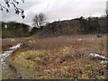
2
Mucky Mountains Nature Reserve
This is a view across Mucky Mountains Nature Reserve with a part of the old Sankey/St.Helens Canal to the right. The Mucky Mountains were formed from waste created by Muspratt's Vitriol Works.
Image: © andy
Taken: 27 Jul 2005
0.14 miles
3
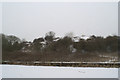
Clean-up of the Mucky Mountains
The snow gives an Alpine appearance to the mounds of chemical waste.
Image: © David Long
Taken: 8 Feb 2007
0.16 miles
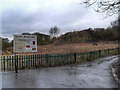
4
Mucky Mountains
The opening of the Sankey Canal in 1757 was the catalyst for the major industrial development of the area. Mucky Mountains are heaps of chemical waste, the by-product of soda made in the 1830s using the inefficient Leblanc Process http://en.wikipedia.org/wiki/Leblanc_process .
Muspratt’s Vitriol Works http://www.n-le-w.co.uk/index.php?option=com_content&task=view&id=43&Itemid=27 produced two tons of waste for every ton of soda it made. Large volumes of hydrochloric acid were discharged into the canal and solid wastes were dumped on nearby land forming large mounds. It is reported that conditions in the alkali works (which closed in 1851) were so bad that the escaping gases caused men’s’ teeth to rot and burned their clothes.
Image: © David Dixon
Taken: 28 Jan 2013
0.17 miles
5
Mucky Mountains, Sankey Valley Park
The opening of the Sankey Canal in 1757 was the catalyst for the major industrial development of the area. Mucky Mountains are heaps of chemical waste, the by-product of soda made in the 1830s using the inefficient Leblanc Process http://en.wikipedia.org/wiki/Leblanc_process .
Muspratt’s Vitriol Works http://www.n-le-w.co.uk/index.php?option=com_content&task=view&id=43&Itemid=27 produced two tons of waste for every ton of soda it made. Large volumes of hydrochloric acid were discharged into the canal and solid wastes were dumped on nearby land forming large mounds. It is reported that conditions in the alkali works (which closed in 1851) were so bad that the escaping gases caused men’s’ teeth to rot and burned their clothes.
Image: © David Dixon
Taken: 28 Jan 2013
0.17 miles
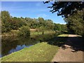
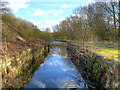
6
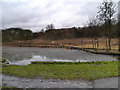
The Sankey Canal and Mucky Mountains
Looking over the Sankey Canal towards the Mucky Mountains Nature Reserve.
The Sankey Canal (which is also known as the Sankey Brook Navigation) ran along the valley of the Sankey Brook from the point where the brook joined the River Mersey, to a location to the north east of St Helens.
The opening of the canal in 1757 was the catalyst for the major industrial development of the area. Mucky Mountains are heaps of chemical waste, the by-product of soda made in the 1830s using the inefficient Leblanc Process http://en.wikipedia.org/wiki/Leblanc_process .
Muspratt’s Vitriol Works http://www.n-le-w.co.uk/index.php?option=com_content&task=view&id=43&Itemid=27 produced two tons of waste for every ton of soda it made. Large volumes of hydrochloric acid were discharged into the canal and solid wastes were dumped on nearby land forming large mounds. It is reported that conditions in the alkali works (which closed in 1851) were so bad that the escaping gases caused men’s’ teeth to rot and burned their clothes.
Image: © David Dixon
Taken: 28 Jan 2013
0.17 miles
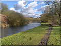
7
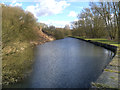
The Sankey Canal
The Sankey Canal, west of Bradley (Bradlegh) Lock.
Image: © David Dixon
Taken: 2 Feb 2013
0.19 miles
8
Sankey Canal, Bradley (Bradlegh) Lock
Behind the camera (ie to the east of here) the canal has been filled in. This is the remains of Bradley Lock with its stone walls. Although named "Bradley" on recent maps, its original name was "Bradlegh" and a local signpost uses that spelling.
Image: © David Dixon
Taken: 2 Feb 2013
0.19 miles