IMAGES TAKEN NEAR TO
Warrington Road, NEWTON-LE-WILLOWS, WA12 0HZ
Introduction
This page details the photographs taken nearby to Warrington Road, WA12 0HZ by members of the Geograph project.
The Geograph project started in 2005 with the aim of publishing, organising and preserving representative images for every square kilometre of Great Britain, Ireland and the Isle of Man.

There are currently over 7.5m images from over14,400 individuals and you can help contribute to the project by visiting https://www.geograph.org.uk
Image Map
Images are licensed for reuse under creativecommons.org/licenses/by-sa/2.0
Notes
- Clicking on the map will re-center to the selected point.
- The higher the marker number, the further away the image location is from the centre of the postcode.
Image Listing (13 Images Found)
Images are licensed for reuse under creativecommons.org/licenses/by-sa/2.0
Image
Details
Distance
1
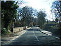
Warrington Road
The A573 (Warrington Road), to the south of Golborne and the East Lancs Road.
Image: © David Dixon
Taken: 21 Feb 2012
0.02 miles
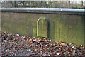
2
Golbourne Dale Bridge
According to the map it's Golborne Dale Bridge, but carved into the plate visible on the left (see next pic) it is spelt with a 'u'.
Image: © David Long
Taken: 2 Jan 2009
0.10 miles
4
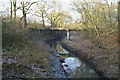
Millingford Brook
From Golbourne Dale Bridge. It serves here as the boundary between Wigan and St Helens.
Image: © David Long
Taken: 2 Jan 2009
0.12 miles
5
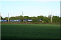
CO2 is less with DRS
A Direct Rail Services train comprising a class 66 loco (424) and 10 megafret wagons carrying 20 45ft swapbodies for Tesco and Stobart Rail. 20 HGVs less on the M6 !
Image: © David Ashcroft
Taken: 9 May 2009
0.12 miles
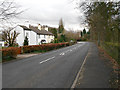
6
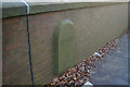
Boundary stone for Newton-le-Willows (St Helens Borough)
Image: © David Long
Taken: 2 Jan 2009
0.13 miles

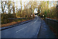
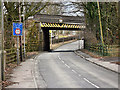
8
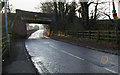
The West Coast Main Line bridge over the A573
At the point from which the shot was taken the road changes from being called Warrington Road (Wigan) to Golborne Dale Road (Warrington). The signs on the post relate to opposition to develop the nearby site of Parkside Colliery as a rail/road distribution centre.
Image: © David Long
Taken: 2 Jan 2009
0.14 miles
9
Golborne Dale Bridge
The mainline railway crossing the A573, Golborne Dale Road.
Image: © David Dixon
Taken: 21 Feb 2012
0.16 miles