IMAGES TAKEN NEAR TO
Wetherby Close, NEWTON-LE-WILLOWS, WA12 0BW
Introduction
This page details the photographs taken nearby to Wetherby Close, WA12 0BW by members of the Geograph project.
The Geograph project started in 2005 with the aim of publishing, organising and preserving representative images for every square kilometre of Great Britain, Ireland and the Isle of Man.

There are currently over 7.5m images from over14,400 individuals and you can help contribute to the project by visiting https://www.geograph.org.uk
Image Map
Images are licensed for reuse under creativecommons.org/licenses/by-sa/2.0
Notes
- Clicking on the map will re-center to the selected point.
- The higher the marker number, the further away the image location is from the centre of the postcode.
Image Listing (12 Images Found)
Images are licensed for reuse under creativecommons.org/licenses/by-sa/2.0
Image
Details
Distance
1
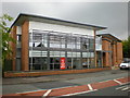
Pavilions, Newton-le-Willows Cricket Ground
Image: © Alexander P Kapp
Taken: 19 May 2009
0.16 miles
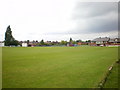
2
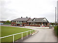
Newton-le-willows Cricket Ground, Memorial
Image: © Alexander P Kapp
Taken: 19 May 2009
0.16 miles
3
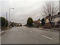
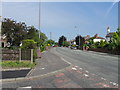
Ashton Road (A49)
Ashton Road (A49), Newton-le-Willows.
Image: © David Dixon
Taken: 28 Jan 2013
0.16 miles
7
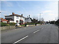
A49, Ashton Road
North of Newton Le Willows.
Image: © Richard Webb
Taken: 22 Mar 2022
0.21 miles
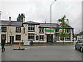
9
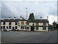
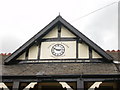
The Oak Tree, Newton-le-Willows
The Oak Tree Inn at the junction of Crow Lane East with High Street, Newton-le-Willows. It is supposed to have been built on the site of Oak Tree Hall, which was demolished in the early 1700's.
Image: © Sue Adair
Taken: 22 Jul 2007
0.22 miles