IMAGES TAKEN NEAR TO
Southworth Road, NEWTON-LE-WILLOWS, WA12 0BS
Introduction
This page details the photographs taken nearby to Southworth Road, WA12 0BS by members of the Geograph project.
The Geograph project started in 2005 with the aim of publishing, organising and preserving representative images for every square kilometre of Great Britain, Ireland and the Isle of Man.

There are currently over 7.5m images from over14,400 individuals and you can help contribute to the project by visiting https://www.geograph.org.uk
Image Map
Images are licensed for reuse under creativecommons.org/licenses/by-sa/2.0
Notes
- Clicking on the map will re-center to the selected point.
- The higher the marker number, the further away the image location is from the centre of the postcode.
Image Listing (32 Images Found)
Images are licensed for reuse under creativecommons.org/licenses/by-sa/2.0
Image
Details
Distance
2
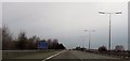
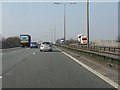
Motorway Bridge, Southworth Road
The M6 motorway crossing over the A572 (Southworth Road) between Golborne and Newton-le-Willows.
Image: © David Dixon
Taken: 21 Feb 2012
0.05 miles
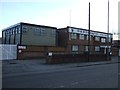
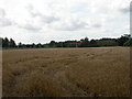
4
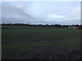
Farmland off Southworth Road
Towards the railway.
Image: © JThomas
Taken: 16 Feb 2013
0.07 miles
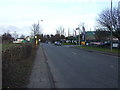
5
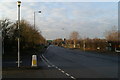
The A572 on the edge of Newton-le-Willows
The M6 crosses in the distance, the A573 goes off to Warrington on the left.
Image: © David Long
Taken: 2 Jan 2009
0.10 miles
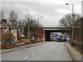
6
M6 motorway crossing the Liverpool & Manchester Railway
The 1830 railway line is bridged by the 1963 motorway.
Image: © Peter Whatley
Taken: 24 Mar 2011
0.10 miles
7
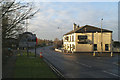
Dog-leg junction
The A573 travels right to left between Wigan and Warrington, meeting the A572 Lowton - Newton road at the Wigan/ St Helens boundary. Note the new boundary sign, depicting the Earlestown Viaduct, which carried the Liverpool-Manchester Railway (the first purpose-built passenger railway in the world) over the Sankey Brook Navigation (England's first true canal of the Industrial Revolution).
Image: © David Long
Taken: 2 Jan 2009
0.14 miles
8
Town of Lowton, cornfield
Cornfield looking ready for harvesting; to the left, railway electricity gantries, to the right, lorries on M6.
Image: © Mike Faherty
Taken: 1 Sep 2009
0.15 miles
9
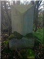
Old Milestone by the A573, Parkside Road, Newton le Willows Parish
Carved stone post by the A573, in parish of NEWTON LE WILLOWS (ST HELENS District), Parkside Road, Town of Lowton, 30m South of junction with Southwold Road, on West side of road in undergrowth. Lancs CC stone triangle, erected by the County Council in the 19th/20th century.
Inscription reads:- : WIGAN / 7 MILES. : : NEWTON : : WARRINGTON / 5 MILES. :
Milestone Society National ID: LA_WGWA07.
Image: © J Higgins
Taken: 1 Sep 2008
0.15 miles