1
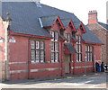
Warrington - buildings on Wilson Patten Street
Around junction with Arpley Street. For an alternative view, please see
Image
Image: © Dave Bevis
Taken: 18 Feb 2013
0.05 miles
2
Warrington Pyramid
A multi-purpose arts venue for Warrington which opened in 2002. A former courthouse was converted and a modern foyer added. It is Warrington's first dedicated arts venue.
Image: © Eirian Evans
Taken: 14 May 2009
0.05 miles
3
Police Station, Warrington
Old Victorian Police Station on Arpley Road, which was opened in 1901 to house a police station and court house.
Image: © Eirian Evans
Taken: 14 May 2009
0.06 miles
4
Warrington - former school on Hanover Street
Image: © Dave Bevis
Taken: 18 Feb 2013
0.06 miles
5
Housing, Arpley Street, Warrington
Terraced housing on Arpley Street, Warrington.
Image: © William Starkey
Taken: 24 Aug 2014
0.06 miles
6
County Court Warrington
Erected in 1897, the former County Court and Inland Revenue building at the junction of Winmarleigh Street and Palmyra Square, Warrington.
Image: © Sue Adair
Taken: 2 Feb 2008
0.06 miles
7
Warrington - former county court on Hanover Street
For an alternative view, please see
Image
Image: © Dave Bevis
Taken: 18 Feb 2013
0.06 miles
8
Arpley Street, Warrington
This terrace of houses, located just north of the junction with Museum Street, is very close to the heart of the town centre, but still appears to be in residential use.
Image: © Richard Vince
Taken: 28 Jul 2012
0.07 miles
9
Warrington Police Station
Warrington's rather grand central police station, on the corner of Arpley Street (right) and Wilson Patten Street.
Image: © Richard Vince
Taken: 28 Jul 2012
0.07 miles
10
North end of Slutchers Lane, Warrington
Seen from its junction with Wilson Patten Street, Slutchers Lane provides access to a car park associated with Bank Quay station (a few minutes' walk west) and to an important rail freight facility.
Image: © Richard Vince
Taken: 28 Jul 2012
0.07 miles


