IMAGES TAKEN NEAR TO
Penny Lane, ST. HELENS, WA11 9ST
Introduction
This page details the photographs taken nearby to Penny Lane, WA11 9ST by members of the Geograph project.
The Geograph project started in 2005 with the aim of publishing, organising and preserving representative images for every square kilometre of Great Britain, Ireland and the Isle of Man.

There are currently over 7.5m images from over14,400 individuals and you can help contribute to the project by visiting https://www.geograph.org.uk
Image Map
Images are licensed for reuse under creativecommons.org/licenses/by-sa/2.0
Notes
- Clicking on the map will re-center to the selected point.
- The higher the marker number, the further away the image location is from the centre of the postcode.
Image Listing (15 Images Found)
Images are licensed for reuse under creativecommons.org/licenses/by-sa/2.0
Image
Details
Distance
1
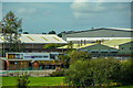
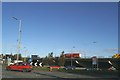
Ashton-in-Makerfield : Old Boston Trading Estate
Looking across to a trading estate in New Boston.
Image: © Lewis Clarke
Taken: 23 Sep 2019
0.10 miles
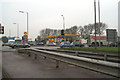
6
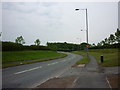
Penny Lane at Old Boston Haydock
The East Lancs Road bridge seen in distance
Image: © Raymond Knapman
Taken: 10 Sep 2010
0.17 miles
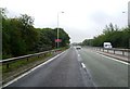
7
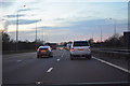
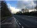
St Helens : The M6 Motorway
Heading north along the M6 Motorway as it heads through Merseyside.
Image: © Lewis Clarke
Taken: 21 Apr 2016
0.18 miles
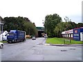
8
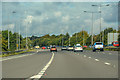
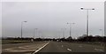
Ashton-in-Makerfield : M6 Motorway
The M6 Motorway between Junction 23 (Haydock) and Junction 24.
Image: © Lewis Clarke
Taken: 23 Sep 2019
0.18 miles