IMAGES TAKEN NEAR TO
Liverpool Road, ST. HELENS, WA11 9SD
Introduction
This page details the photographs taken nearby to Liverpool Road, WA11 9SD by members of the Geograph project.
The Geograph project started in 2005 with the aim of publishing, organising and preserving representative images for every square kilometre of Great Britain, Ireland and the Isle of Man.

There are currently over 7.5m images from over14,400 individuals and you can help contribute to the project by visiting https://www.geograph.org.uk
Image Map
Images are licensed for reuse under creativecommons.org/licenses/by-sa/2.0
Notes
- Clicking on the map will re-center to the selected point.
- The higher the marker number, the further away the image location is from the centre of the postcode.
Image Listing (16 Images Found)
Images are licensed for reuse under creativecommons.org/licenses/by-sa/2.0
Image
Details
Distance
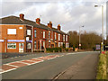
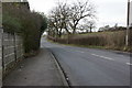
1
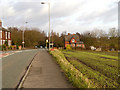
Liverpool Road, Pewfall
The A58 (Liverpool Road) near to the site of the former Pewfall Colliery http://www.cmhrc.co.uk/site/scrapbook/ashtoninmakerfield/pewfallcolliery/index.html .
Image: © David Dixon
Taken: 31 Jan 2013
0.02 miles
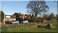
2
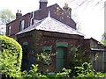
Pewfall Coal Mine Office
This building was once used as a miners wage office.This is all that remains of the extensive Pewfall coal pits and railway system.It lies alongside the A58.
Image: © Raymond Knapman
Taken: 7 May 2008
0.05 miles
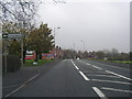
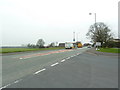
4
Liverpool Road/Garswood Road Junction, Pewfall
Liverpool Road (A58) near the site of the old Pewfall Colliery http://www.cmhrc.co.uk/site/scrapbook/ashtoninmakerfield/pewfallcolliery/index.html .
Image: © David Dixon
Taken: 31 Jan 2013
0.06 miles
5
Liverpool Road at Pewfall
Looking southwest
Image: © Alexander P Kapp
Taken: 14 Mar 2012
0.08 miles
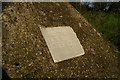
9
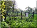
Capped Mineshaft
On public footpath between A58 and Garswood Road
Image: © Raymond Knapman
Taken: 7 May 2008
0.15 miles