IMAGES TAKEN NEAR TO
Renfrew Avenue, ST. HELENS, WA11 9RW
Introduction
This page details the photographs taken nearby to Renfrew Avenue, WA11 9RW by members of the Geograph project.
The Geograph project started in 2005 with the aim of publishing, organising and preserving representative images for every square kilometre of Great Britain, Ireland and the Isle of Man.

There are currently over 7.5m images from over14,400 individuals and you can help contribute to the project by visiting https://www.geograph.org.uk
Image Map
Images are licensed for reuse under creativecommons.org/licenses/by-sa/2.0
Notes
- Clicking on the map will re-center to the selected point.
- The higher the marker number, the further away the image location is from the centre of the postcode.
Image Listing (30 Images Found)
Images are licensed for reuse under creativecommons.org/licenses/by-sa/2.0
Image
Details
Distance
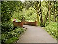
2
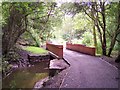
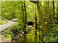
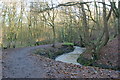
Bridge over Black Brook in Stanley Bank wood
Image: © Raymond Knapman
Taken: 23 Jul 2010
0.04 miles
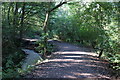
5
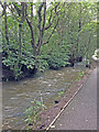
Black Brook in spate
Working hard to clear the recent heavy rainfall
Image: © Ian Greig
Taken: 17 Aug 2019
0.06 miles
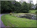
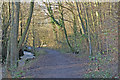
9
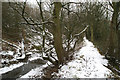
The Carr & Stanley Canal
This short, half-mile canal, which is close to the terminus of the Sankey Canal, (see Image) was only recently placed on the list of known canals in Britain. It served the Stanley Iron Slitting Mill to the south, bringing coal and materials from another part of the iron works at Carr to the north. The snow enables its construction to be seen more clearly - material from the hillside on the left having been dug out and piled up to form the lower bank, upon which was the towpath for hauling boats.
Image: © David Long
Taken: 8 Feb 2007
0.12 miles