IMAGES TAKEN NEAR TO
O'Sullivan Crescent, ST. HELENS, WA11 9RB
Introduction
This page details the photographs taken nearby to O'Sullivan Crescent, WA11 9RB by members of the Geograph project.
The Geograph project started in 2005 with the aim of publishing, organising and preserving representative images for every square kilometre of Great Britain, Ireland and the Isle of Man.

There are currently over 7.5m images from over14,400 individuals and you can help contribute to the project by visiting https://www.geograph.org.uk
Image Map (Loading...)


Getting Data...Please wait
Leaflet Map data © OpenStreetMap
Images are licensed for reuse under creativecommons.org/licenses/by-sa/2.0
Notes
- Clicking on the map will re-center to the selected point.
- The higher the marker number, the further away the image location is from the centre of the postcode.
Image Listing (28 Images Found)
Images are licensed for reuse under creativecommons.org/licenses/by-sa/2.0
Image
Details
Distance

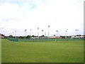
3
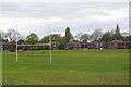
Recreation ground South of O'Sullivan Crescent, Blackbrook
Image: © Gary Rogers
Taken: 29 Apr 2017
0.15 miles
4
School playing field illumination masts
Image: © Raymond Knapman
Taken: 23 Jul 2010
0.18 miles
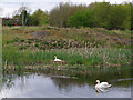
6
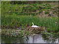
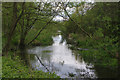
Swan's nest, St Helens Canal, Blackbrook
Image: © Gary Rogers
Taken: 29 Apr 2017
0.18 miles
7
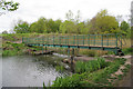
Footbridge over St Helens Canal, Blackbrook
Image: © Gary Rogers
Taken: 29 Apr 2017
0.19 miles
8

Modern Canal Milestone, Sankey Canal
On the towpath of the Blackbrook extension. SE of Blackbrook Road/Stanley Bank (A58).
Milestone Society National ID: SAN-10AR
Image: © Barrie Pennington
Taken: 10 Jan 2019
0.19 miles