IMAGES TAKEN NEAR TO
Grasmere Court, ST. HELENS, WA11 9PR
Introduction
This page details the photographs taken nearby to Grasmere Court, WA11 9PR by members of the Geograph project.
The Geograph project started in 2005 with the aim of publishing, organising and preserving representative images for every square kilometre of Great Britain, Ireland and the Isle of Man.

There are currently over 7.5m images from over14,400 individuals and you can help contribute to the project by visiting https://www.geograph.org.uk
Image Map
Images are licensed for reuse under creativecommons.org/licenses/by-sa/2.0
Notes
- Clicking on the map will re-center to the selected point.
- The higher the marker number, the further away the image location is from the centre of the postcode.
Image Listing (17 Images Found)
Images are licensed for reuse under creativecommons.org/licenses/by-sa/2.0
Image
Details
Distance
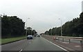
1
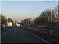
A580 - view east from Scafell Road bridge
Image: © Peter Whatley
Taken: 17 Jan 2012
0.11 miles
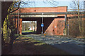
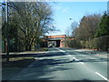
3
Former railway bridge abutment
On Washway Lane, the former bridge was for the St Helens to Rainford Junction route
Image: © Kevin Waterhouse
Taken: 2 Jan 2025
0.15 miles
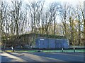
4
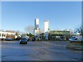
Industrial gases plant
On Washway Lane
Image: © Kevin Waterhouse
Taken: 2 Jan 2025
0.15 miles