IMAGES TAKEN NEAR TO
Irene Avenue, ST. HELENS, WA11 9AW
Introduction
This page details the photographs taken nearby to Irene Avenue, WA11 9AW by members of the Geograph project.
The Geograph project started in 2005 with the aim of publishing, organising and preserving representative images for every square kilometre of Great Britain, Ireland and the Isle of Man.

There are currently over 7.5m images from over14,400 individuals and you can help contribute to the project by visiting https://www.geograph.org.uk
Image Map
Images are licensed for reuse under creativecommons.org/licenses/by-sa/2.0
Notes
- Clicking on the map will re-center to the selected point.
- The higher the marker number, the further away the image location is from the centre of the postcode.
Image Listing (20 Images Found)
Images are licensed for reuse under creativecommons.org/licenses/by-sa/2.0
Image
Details
Distance
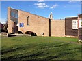
4
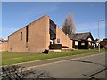
United Reformed Church, Derwent Road, Haresfinch
Image: © David Dixon
Taken: 10 Mar 2014
0.16 miles

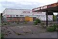
8
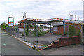
Disused Petrol Station and United Footwear Outlet on Carr Mill Road
Image: © Gary Rogers
Taken: 29 Apr 2017
0.22 miles
9
Former Petrol Station on Carr Mill Road
Image: © David Dixon
Taken: 10 Mar 2014
0.23 miles
10
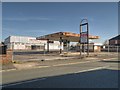
Disused Burmah Petrol Station and United Footwear Outlet on Carr Mill Road
Image: © Gary Rogers
Taken: 29 Apr 2017
0.23 miles