IMAGES TAKEN NEAR TO
Red Cat Lane, ST. HELENS, WA11 8RR
Introduction
This page details the photographs taken nearby to Red Cat Lane, WA11 8RR by members of the Geograph project.
The Geograph project started in 2005 with the aim of publishing, organising and preserving representative images for every square kilometre of Great Britain, Ireland and the Isle of Man.

There are currently over 7.5m images from over14,400 individuals and you can help contribute to the project by visiting https://www.geograph.org.uk
Image Map
Images are licensed for reuse under creativecommons.org/licenses/by-sa/2.0
Notes
- Clicking on the map will re-center to the selected point.
- The higher the marker number, the further away the image location is from the centre of the postcode.
Image Listing (15 Images Found)
Images are licensed for reuse under creativecommons.org/licenses/by-sa/2.0
Image
Details
Distance
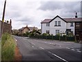
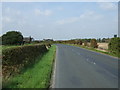
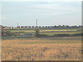
2
Red Cat Lane from Alder Lane, Crank
Image: © Mike Pennington
Taken: 24 Mar 2019
0.10 miles
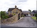
4
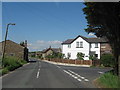
Red Cat Lane, Crank
The junction of Red Cat Lane and Gore's Lane, Crank. The white house on the right is Old Bull Cottage.
Image: © Sue Adair
Taken: 5 Jun 2007
0.13 miles
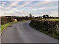
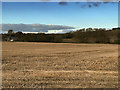
6
Billinge
View south west from the T junction at Kings Moss in the north of the square.
Image: © Gary Rogers
Taken: 16 Jun 2005
0.14 miles