IMAGES TAKEN NEAR TO
Crank Road, ST. HELENS, WA11 8RB
Introduction
This page details the photographs taken nearby to Crank Road, WA11 8RB by members of the Geograph project.
The Geograph project started in 2005 with the aim of publishing, organising and preserving representative images for every square kilometre of Great Britain, Ireland and the Isle of Man.

There are currently over 7.5m images from over14,400 individuals and you can help contribute to the project by visiting https://www.geograph.org.uk
Image Map
Images are licensed for reuse under creativecommons.org/licenses/by-sa/2.0
Notes
- Clicking on the map will re-center to the selected point.
- The higher the marker number, the further away the image location is from the centre of the postcode.
Image Listing (32 Images Found)
Images are licensed for reuse under creativecommons.org/licenses/by-sa/2.0
Image
Details
Distance
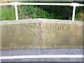
3
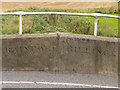
Old Boundary Marker on King's Bridge, Rainford parish
Parish Boundary Marker by the UC road, in parish of Rainford (St Helens District), King's Bridge, Black Brook. Crank Road, Kings Moss, on West bridge parapet.
Inscription reads:-
RAINFORD | BILLINGE
Surveyed
Milestone Society National ID: LA_RAIN01pb
Image: © Milestone Society
Taken: Unknown
0.05 miles
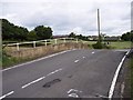
5
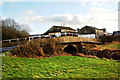
Old Bridge Marker on King's Bridge, Crank Road, Rainford parish
Bridge Marker by the UC road, in parish of Rainford (St Helens District), King's Bridge, Black Brook, Crank Road, King's Moss, on East bridge parapet.
Inscription reads:-
C.C. KINGS BRIDGE
Surveyed
Milestone Society National ID: LA_RAIN02br
Image: © Milestone Society
Taken: Unknown
0.06 miles
7
Boundary Bridge over Black Brook
Inscription reads Billinge/Rainford on bridge parapet
Image: © Raymond Knapman
Taken: 29 Jun 2008
0.07 miles
9
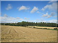
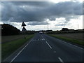
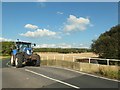
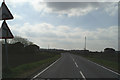
Crank Road and Billinge Hill
Looking from the Kings Moss Road across newly harvested fields towards Crank Road as it ascends Billinge Hill.
Image: © Sue Adair
Taken: 2 Sep 2013
0.08 miles