IMAGES TAKEN NEAR TO
Ferny Knoll Road, ST. HELENS, WA11 7TQ
Introduction
This page details the photographs taken nearby to Ferny Knoll Road, WA11 7TQ by members of the Geograph project.
The Geograph project started in 2005 with the aim of publishing, organising and preserving representative images for every square kilometre of Great Britain, Ireland and the Isle of Man.

There are currently over 7.5m images from over14,400 individuals and you can help contribute to the project by visiting https://www.geograph.org.uk
Image Map
Images are licensed for reuse under creativecommons.org/licenses/by-sa/2.0
Notes
- Clicking on the map will re-center to the selected point.
- The higher the marker number, the further away the image location is from the centre of the postcode.
Image Listing (14 Images Found)
Images are licensed for reuse under creativecommons.org/licenses/by-sa/2.0
Image
Details
Distance
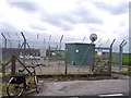
3
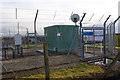
An unodourised gas installation at Ferny Knoll
I'd forgotten natural gas needed the smell adding
Image: © Ian Greig
Taken: 14 Nov 2010
0.08 miles
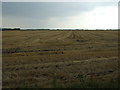
6
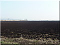
Ploughed field on the southeast side of Ferny Knoll Road
Image: © Alexander P Kapp
Taken: 28 Mar 2011
0.14 miles