IMAGES TAKEN NEAR TO
Siding Lane, ST. HELENS, WA11 7SR
Introduction
This page details the photographs taken nearby to Siding Lane, WA11 7SR by members of the Geograph project.
The Geograph project started in 2005 with the aim of publishing, organising and preserving representative images for every square kilometre of Great Britain, Ireland and the Isle of Man.

There are currently over 7.5m images from over14,400 individuals and you can help contribute to the project by visiting https://www.geograph.org.uk
Image Map
Images are licensed for reuse under creativecommons.org/licenses/by-sa/2.0
Notes
- Clicking on the map will re-center to the selected point.
- The higher the marker number, the further away the image location is from the centre of the postcode.
Image Listing (11 Images Found)
Images are licensed for reuse under creativecommons.org/licenses/by-sa/2.0
Image
Details
Distance
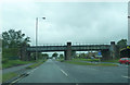
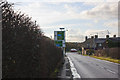
3
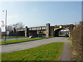
Bridges
Over Ormskirk Road on the right and Rainford By-pass on the left
Image: © Alexander P Kapp
Taken: 28 Mar 2011
0.09 miles
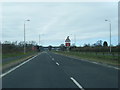
4
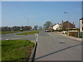
Ormskirk Road
With Rainford By-pass on the left
Image: © Alexander P Kapp
Taken: 28 Mar 2011
0.12 miles
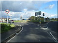
9
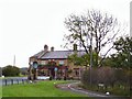
Wheatsheaf
Pub of the Year on the roundabout at Park Hill adjacent to the Rainford Bypass.
Image: © Roger May
Taken: 28 Oct 2005
0.23 miles
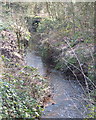
10
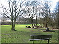
Site of Rainford Colliery (Siding Lane Local Nature Reserve)
Siding Lane Local Nature Reserve occupies the site of the former Rainford Colliery. The shaft was sunk through sixteen feet of wet gravel and sand in 1860 and operated until the 1926 coal strike which caused the decline of the pit, finally closing in 1928.
Image: © Sue Adair
Taken: 10 Mar 2009
0.24 miles