IMAGES TAKEN NEAR TO
Alder Lane, ST. HELENS, WA11 7SH
Introduction
This page details the photographs taken nearby to Alder Lane, WA11 7SH by members of the Geograph project.
The Geograph project started in 2005 with the aim of publishing, organising and preserving representative images for every square kilometre of Great Britain, Ireland and the Isle of Man.

There are currently over 7.5m images from over14,400 individuals and you can help contribute to the project by visiting https://www.geograph.org.uk
Image Map
Images are licensed for reuse under creativecommons.org/licenses/by-sa/2.0
Notes
- Clicking on the map will re-center to the selected point.
- The higher the marker number, the further away the image location is from the centre of the postcode.
Image Listing (19 Images Found)
Images are licensed for reuse under creativecommons.org/licenses/by-sa/2.0
Image
Details
Distance
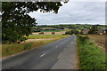
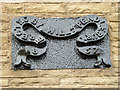
2
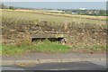
Unusual lintel feature in dry stone wall on Alder Lane, Billinge
Image: © Gary Rogers
Taken: 8 Oct 2014
0.03 miles
3
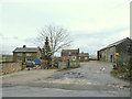
Alderley Farm Barn, Alder Lane, Billinge
Image: © Gary Rogers
Taken: 8 Oct 2014
0.07 miles

5
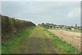
Track between Alder Lane and Rainford Old Delph (Crank caverns), Billinge
Image: © Gary Rogers
Taken: 8 Oct 2014
0.09 miles
7
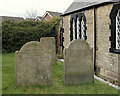
Late 19th Century Grave Stones of Joseph Spencer and William Pendlebury at Alder Lane Mission
Alder Lane, Crank
Image: © Gary Rogers
Taken: 20 Feb 2015
0.16 miles
8
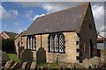
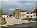
Alder Lane Mission, Crank
This church was built by William Pendlebury in 1857. His grave lies next to the building.
Image: © Gary Rogers
Taken: 2 Oct 2008
0.16 miles
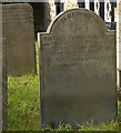
10
Alder Lane Mission erected by...
William Pendlebury in 1867
Image: © Gary Rogers
Taken: 20 Feb 2015
0.17 miles