IMAGES TAKEN NEAR TO
Garswood Old Road, ST. HELENS, WA11 7NA
Introduction
This page details the photographs taken nearby to Garswood Old Road, WA11 7NA by members of the Geograph project.
The Geograph project started in 2005 with the aim of publishing, organising and preserving representative images for every square kilometre of Great Britain, Ireland and the Isle of Man.

There are currently over 7.5m images from over14,400 individuals and you can help contribute to the project by visiting https://www.geograph.org.uk
Image Map
Images are licensed for reuse under creativecommons.org/licenses/by-sa/2.0
Notes
- Clicking on the map will re-center to the selected point.
- The higher the marker number, the further away the image location is from the centre of the postcode.
Image Listing (51 Images Found)
Images are licensed for reuse under creativecommons.org/licenses/by-sa/2.0
Image
Details
Distance
1
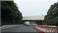
Repair Works on Railway Bridge over the A580
Image: © Anthony Parkes
Taken: 23 Sep 2012
0.02 miles
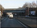
2
Railway Bridge over the East Lancs Road
Image: © David Dixon
Taken: 10 Mar 2014
0.02 miles
3
Railway overbridge, A580
The bridge carries the St. Helens-Wigan North Western line.
Image: © Peter Whatley
Taken: 17 Jan 2012
0.04 miles
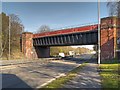
5

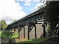
Railway Viaduct over Black Brook
The recently restored Lancashire Union Railway bridge/viaduct over Black Brook dates from 1869. The Lancashire Union Railway line ran from St Helens to Blackburn. The only part of the line still in use is the section between St Helens and Wigan.
Image: © David Dixon
Taken: 18 May 2014
0.06 miles
6
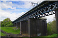
Restoration Complete
The recently restored Lancashire Union Railway bridge over Black Brook dates from 1869
The Lancashire Union Railway line ran from St. Helens to Blackburn. The only part of the line now in use is this section between St. Helens and Wigan.
Image: © K A
Taken: 22 Aug 2010
0.06 miles
7

Carr Mill Dam Overflow
The dam has two overflows feeding into the blackbrook basin which, in turn, leads to the Blackbrook Canal, a part of the Sankey Navigation. The newer of the two overflows is pictured here.
Image: © David Dixon
Taken: 18 May 2014
0.06 miles
9
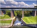
Carr Mill Railway Viaduct and Overflow From Carr Mill Dam
The dam has two overflows feeding into the blackbrook basin which, in turn, leads to the Blackbrook Canal, a part of the Sankey Navigation. The newer of the two overflows is pictured here. The recently restored bridge/viaduct, which dates from the mid-nineteenth century, carries the St Helens to Wigan railway line.
Compare this view with Image] taken in 2005, before the bridge was restored.
Image: © David Dixon
Taken: 18 May 2014
0.07 miles
10
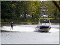
Water Skier, Carr Mill Dam
Water skiers can be seen on the dam on many sunny evenings and weekends. Water Skiing is run by, and is an active section of, the Lancashire Powerboat Racing Club, who also, occasionally, hold water Ski jumping competitions.
Image: © David Dixon
Taken: 18 May 2014
0.08 miles