IMAGES TAKEN NEAR TO
Dairy Farm Road, ST. HELENS, WA11 7JJ
Introduction
This page details the photographs taken nearby to Dairy Farm Road, WA11 7JJ by members of the Geograph project.
The Geograph project started in 2005 with the aim of publishing, organising and preserving representative images for every square kilometre of Great Britain, Ireland and the Isle of Man.

There are currently over 7.5m images from over14,400 individuals and you can help contribute to the project by visiting https://www.geograph.org.uk
Image Map
Images are licensed for reuse under creativecommons.org/licenses/by-sa/2.0
Notes
- Clicking on the map will re-center to the selected point.
- The higher the marker number, the further away the image location is from the centre of the postcode.
Image Listing (7 Images Found)
Images are licensed for reuse under creativecommons.org/licenses/by-sa/2.0
Image
Details
Distance
3
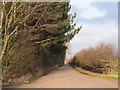
Dairy Farm Road at Nursery Plantation, Rainford
Image: © Gary Rogers
Taken: 26 Feb 2016
0.12 miles
4
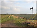
Path at Nursery Plantation, Rainford
From Dairy Farm Lane to the railway crossing point near Siding Lane Nature Reserve
Image: © Gary Rogers
Taken: 26 Feb 2016
0.17 miles
5
Path from Dairy Farm Lane to Inglenook Farm, Rainford
Image: © Gary Rogers
Taken: 26 Feb 2016
0.19 miles
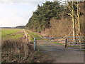
7
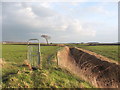
Gated path between Dairy Farm Road and Inglenook Farm
The gate allows access to the path through the field which has an electric fence around it.
Image: © Gary Rogers
Taken: 26 Feb 2016
0.24 miles