IMAGES TAKEN NEAR TO
Blindfoot Road, ST. HELENS, WA11 7HZ
Introduction
This page details the photographs taken nearby to Blindfoot Road, WA11 7HZ by members of the Geograph project.
The Geograph project started in 2005 with the aim of publishing, organising and preserving representative images for every square kilometre of Great Britain, Ireland and the Isle of Man.

There are currently over 7.5m images from over14,400 individuals and you can help contribute to the project by visiting https://www.geograph.org.uk
Image Map
Images are licensed for reuse under creativecommons.org/licenses/by-sa/2.0
Notes
- Clicking on the map will re-center to the selected point.
- The higher the marker number, the further away the image location is from the centre of the postcode.
Image Listing (9 Images Found)
Images are licensed for reuse under creativecommons.org/licenses/by-sa/2.0
Image
Details
Distance
1
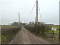
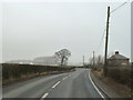
Track to Blind Foot Farm from B5203 Blind Foot Road
Image: © Gary Rogers
Taken: 10 Feb 2015
0.03 miles
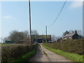
3
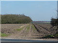
Farmland near Blind Foot Farm, Rainford
Image: © Gary Rogers
Taken: 10 Feb 2015
0.09 miles
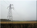
8
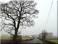
A track cleared at the edge of the crop by Blind Foot Road
Unfortunately the material used as hardcore for the field entrance, which can no doubt be boggy, is not exactly pretty
Image: © Ian Greig
Taken: 10 Jul 2011
0.18 miles
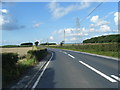
9
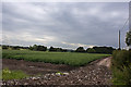
Track to Woodside Farm from B5203 Blind Foot Road
Image: © Gary Rogers
Taken: 10 Feb 2015
0.24 miles