IMAGES TAKEN NEAR TO
Stanley Bank Road, ST. HELENS, WA11 0UP
Introduction
This page details the photographs taken nearby to Stanley Bank Road, WA11 0UP by members of the Geograph project.
The Geograph project started in 2005 with the aim of publishing, organising and preserving representative images for every square kilometre of Great Britain, Ireland and the Isle of Man.

There are currently over 7.5m images from over14,400 individuals and you can help contribute to the project by visiting https://www.geograph.org.uk
Image Map
Images are licensed for reuse under creativecommons.org/licenses/by-sa/2.0
Notes
- Clicking on the map will re-center to the selected point.
- The higher the marker number, the further away the image location is from the centre of the postcode.
Image Listing (26 Images Found)
Images are licensed for reuse under creativecommons.org/licenses/by-sa/2.0
Image
Details
Distance
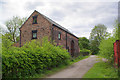
2
Old Barn
This barn is what is left of Stanley bank farm. It is being into a dwelling place. Roman artifacts have been found on the site.
Image: © C Rogers
Taken: 15 Nov 2005
0.02 miles
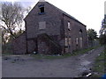
8
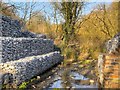
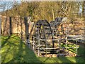
Stanley Iron Slitting Mill, Stanley Bank
Powered by water, Stanley Iron Slitting Mill, built in 1773, heated and rolled iron ingots, forged at Carr Mill, into sheets which were then “slit” into bars for use in the nail-making industry such as at Moss Bank. The mill was demolished in the 1820s and a Corn Mill built in its place, again utilising waterpower. The Corn Mill eventually ceased production by the turn of the 20th Century. Stanley Mill has now been mapped and recorded by the Community Archaeology Society with the help of Liverpool Museum Field Archaeology Unit and conserved as a monument to St.Helens’ industrial heritage using money granted by the Heritage Lottery Fund.
Image: © David Dixon
Taken: 10 Mar 2014
0.19 miles
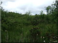
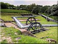
9
Reconstructed Water Wheel at Stanley Mill, Stanley Bank
Powered by water, Stanley Iron Slitting Mill, built in 1773, heated and rolled iron ingots, forged at Carr Mill, into sheets which were then “slit” into bars for use in the nail-making industry such as at Moss Bank. The mill was demolished in the 1820s and a Corn Mill built in its place, again utilising waterpower. The Corn Mill eventually ceased production by the turn of the 20th Century. Stanley Mill has now been mapped and recorded by the Community Archaeology Society with the help of Liverpool Museum Field Archaeology Unit and conserved as a monument to St.Helens’ industrial heritage using money granted by the Heritage Lottery Fund.
Image: © David Dixon
Taken: 10 Mar 2014
0.20 miles
10
Stanley Mill
Powered by water, Stanley Iron Slitting Mill, built in 1773, heated and rolled iron ingots, forged at Carr Mill, into sheets which were then “slit” into bars for use in the nail-making industry such as at Moss Bank. The mill was demolished in the 1820s and a Corn Mill built in its place, again utilising waterpower. The Corn Mill eventually ceased production by the turn of the 20th Century. Stanley Mill has now been mapped and recorded by the Community Archaeology Society with the help of Liverpool Museum Field Archaeology Unit and conserved as a monument to St Helens’ industrial heritage using money granted by the Heritage Lottery Fund.
Image: © David Dixon
Taken: 18 May 2014
0.20 miles