IMAGES TAKEN NEAR TO
Almond Close, ST. HELENS, WA11 0TY
Introduction
This page details the photographs taken nearby to Almond Close, WA11 0TY by members of the Geograph project.
The Geograph project started in 2005 with the aim of publishing, organising and preserving representative images for every square kilometre of Great Britain, Ireland and the Isle of Man.

There are currently over 7.5m images from over14,400 individuals and you can help contribute to the project by visiting https://www.geograph.org.uk
Image Map
Images are licensed for reuse under creativecommons.org/licenses/by-sa/2.0
Notes
- Clicking on the map will re-center to the selected point.
- The higher the marker number, the further away the image location is from the centre of the postcode.
Image Listing (46 Images Found)
Images are licensed for reuse under creativecommons.org/licenses/by-sa/2.0
Image
Details
Distance
1

Modern Canal Milestone, Sankey Canal
On the towpath of the Blackbrook extension. SE of Blackbrook Road/Stanley Bank (A58).
Milestone Society National ID: SAN-10AR
Image: © Barrie Pennington
Taken: 10 Jan 2019
0.06 miles
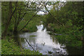
4
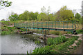
Footbridge over St Helens Canal, Blackbrook
Image: © Gary Rogers
Taken: 29 Apr 2017
0.12 miles
5
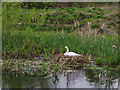
Swan's nest, St Helens Canal, Blackbrook
Image: © Gary Rogers
Taken: 29 Apr 2017
0.15 miles
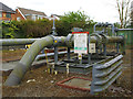
6
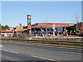
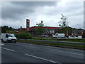
Texaco Service Station near Blackbrook Bridge
Image: © David Dixon
Taken: 10 Mar 2014
0.15 miles
10
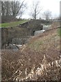
Sankey Valley Park St Helens
Disused canal - set of weirs in old lock.
Image: © Eileen Littler
Taken: 4 Mar 2012
0.16 miles