IMAGES TAKEN NEAR TO
Pimblett Road, ST. HELENS, WA11 0PZ
Introduction
This page details the photographs taken nearby to Pimblett Road, WA11 0PZ by members of the Geograph project.
The Geograph project started in 2005 with the aim of publishing, organising and preserving representative images for every square kilometre of Great Britain, Ireland and the Isle of Man.

There are currently over 7.5m images from over14,400 individuals and you can help contribute to the project by visiting https://www.geograph.org.uk
Image Map
Images are licensed for reuse under creativecommons.org/licenses/by-sa/2.0
Notes
- Clicking on the map will re-center to the selected point.
- The higher the marker number, the further away the image location is from the centre of the postcode.
Image Listing (30 Images Found)
Images are licensed for reuse under creativecommons.org/licenses/by-sa/2.0
Image
Details
Distance
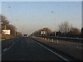
1
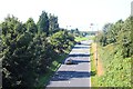
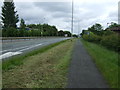
Piele Road, Haydock
Taken from the busy A580 dual carriageway.
Image: © Bob Embleton
Taken: 26 Aug 2013
0.10 miles
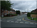
2
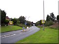
Ex Great Central Railway trackbed used by road at Haydock
The road crosses beneath the East Lancs Road by means of the railway trackbed
Image: © Raymond Knapman
Taken: 13 Aug 2010
0.12 miles
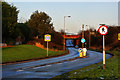
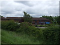
4
Haydock Travelodge
The Travelodge motel at Haydock.
Image: © Peter Mackenzie
Taken: 1 May 2019
0.13 miles
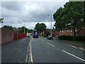
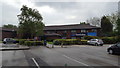
10
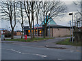
Haydock Library
The Village Library on Church Road.
Image: © David Dixon
Taken: 31 Jan 2013
0.17 miles