IMAGES TAKEN NEAR TO
Station Road, ST. HELENS, WA11 0JN
Introduction
This page details the photographs taken nearby to Station Road, WA11 0JN by members of the Geograph project.
The Geograph project started in 2005 with the aim of publishing, organising and preserving representative images for every square kilometre of Great Britain, Ireland and the Isle of Man.

There are currently over 7.5m images from over14,400 individuals and you can help contribute to the project by visiting https://www.geograph.org.uk
Image Map (Loading...)


Getting Data...Please wait
Leaflet Map data © OpenStreetMap
Images are licensed for reuse under creativecommons.org/licenses/by-sa/2.0
Notes
- Clicking on the map will re-center to the selected point.
- The higher the marker number, the further away the image location is from the centre of the postcode.
Image Listing (21 Images Found)
Images are licensed for reuse under creativecommons.org/licenses/by-sa/2.0
Image
Details
Distance
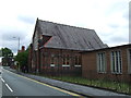
2
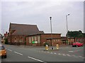
Haydock Methodist Church
Haydock Methodist Church, Clipsley Lane, Haydock. From SJ55609677.
Image: © Keith Williamson
Taken: 9 Sep 2005
0.09 miles
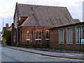
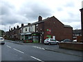
3
Haydock Methodist Church and Sunday School
The corner of Station Road and Clipsey Lane in Haydock.
Image: © David Dixon
Taken: 31 Jan 2013
0.09 miles

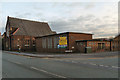
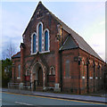
5
Haydock Methodist Church
The large Methodist church on Clipsey Lane.
Image: © David Dixon
Taken: 31 Jan 2013
0.10 miles
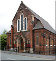
10
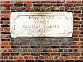
Baptist Chapel Datestone
The stone above the doorway of Image]
PROVIDENCE
STRICT
BAPTIST CHAPEL
1876
Image: © David Dixon
Taken: 31 Jan 2013
0.12 miles