IMAGES TAKEN NEAR TO
West End Road, ST. HELENS, WA11 0AE
Introduction
This page details the photographs taken nearby to West End Road, WA11 0AE by members of the Geograph project.
The Geograph project started in 2005 with the aim of publishing, organising and preserving representative images for every square kilometre of Great Britain, Ireland and the Isle of Man.

There are currently over 7.5m images from over14,400 individuals and you can help contribute to the project by visiting https://www.geograph.org.uk
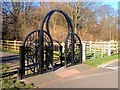
Image Map
Images are licensed for reuse under creativecommons.org/licenses/by-sa/2.0
Notes
- Clicking on the map will re-center to the selected point.
- The higher the marker number, the further away the image location is from the centre of the postcode.
Image Listing (50 Images Found)
Images are licensed for reuse under creativecommons.org/licenses/by-sa/2.0
Image
Details
Distance
1
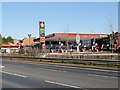
Texaco Service Station near Blackbrook Bridge
Image: © David Dixon
Taken: 10 Mar 2014
0.02 miles
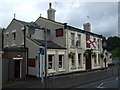
7
The Ship Inn, Blackbrook
The Ship Inn on Blackbrook Road is a good starting point to walk the Sankey Valley.
Image: © Sue Adair
Taken: 22 Jul 2007
0.07 miles
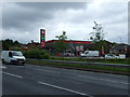
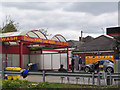
8
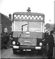
Fire Service 1967
Taken across the road from the petrol station in West End Road
Image: © Mark Riley
Taken: Unknown
0.07 miles
9
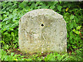
Old Milestone, Sankey Canal
Currently located in the Sankey Valley Visitor Centre.
Inscription: 7 / Mile to / Ferry Lock
Milestone Society National ID: SAN-07
Image: © Barrie Pennington
Taken: 29 Jul 2017
0.07 miles