IMAGES TAKEN NEAR TO
Tennis Street North, ST. HELENS, WA10 6TS
Introduction
This page details the photographs taken nearby to Tennis Street North, WA10 6TS by members of the Geograph project.
The Geograph project started in 2005 with the aim of publishing, organising and preserving representative images for every square kilometre of Great Britain, Ireland and the Isle of Man.

There are currently over 7.5m images from over14,400 individuals and you can help contribute to the project by visiting https://www.geograph.org.uk
Image Map
Images are licensed for reuse under creativecommons.org/licenses/by-sa/2.0
Notes
- Clicking on the map will re-center to the selected point.
- The higher the marker number, the further away the image location is from the centre of the postcode.
Image Listing (20 Images Found)
Images are licensed for reuse under creativecommons.org/licenses/by-sa/2.0
Image
Details
Distance
1
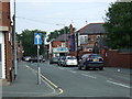
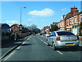
Rivington Road, Denton's Green
Looking north east.
Image: © JThomas
Taken: 13 Sep 2014
0.13 miles
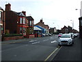
2
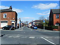
Rivington Road/Dentons Green Lane junction
Image: © Colin Pyle
Taken: 29 Mar 2013
0.15 miles
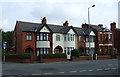
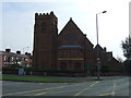
3
St Andrew's Church, St Helens
Built 1907. Architect Frank S Biram.
Image: © S Parish
Taken: 12 Jan 2011
0.15 miles
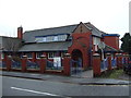
9
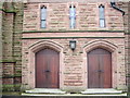
St Thomas of Canterbury, Dentons Green Lane, St Helens, Doorway
Image: © Alexander P Kapp
Taken: 3 Apr 2008
0.20 miles
10
St Thomas Of Canterbury Roman Catholic Church, Denton's Green
Image: © JThomas
Taken: 13 Sep 2014
0.21 miles