IMAGES TAKEN NEAR TO
Windle Grove, ST. HELENS, WA10 6HP
Introduction
This page details the photographs taken nearby to Windle Grove, WA10 6HP by members of the Geograph project.
The Geograph project started in 2005 with the aim of publishing, organising and preserving representative images for every square kilometre of Great Britain, Ireland and the Isle of Man.

There are currently over 7.5m images from over14,400 individuals and you can help contribute to the project by visiting https://www.geograph.org.uk
Image Map
Images are licensed for reuse under creativecommons.org/licenses/by-sa/2.0
Notes
- Clicking on the map will re-center to the selected point.
- The higher the marker number, the further away the image location is from the centre of the postcode.
Image Listing (14 Images Found)
Images are licensed for reuse under creativecommons.org/licenses/by-sa/2.0
Image
Details
Distance
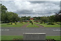
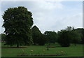
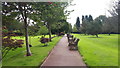
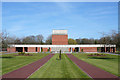
3
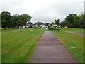
Walkway and lawns, St Helens Crematorium
Image: © Peter Bond
Taken: 31 May 2012
0.07 miles
6
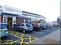
Tesco Express & Fuel Station at A570 / A580 Junction
Image: © Anthony Parkes
Taken: 5 Jan 2012
0.15 miles
7
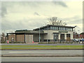
Starbucks at Windle Island on the A580 East Lancs Road
Image: © Gary Rogers
Taken: 20 Feb 2015
0.15 miles
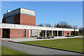
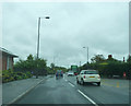
10
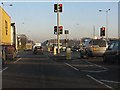
Co-acting traffic lights at the A580/A570 junction
The upper lights are visible over cars, but not trucks and coaches, for some distance on the flat south Lancashire plain.
Image: © Peter Whatley
Taken: 17 Jan 2012
0.19 miles