IMAGES TAKEN NEAR TO
Malt House Court, ST. HELENS, WA10 6DJ
Introduction
This page details the photographs taken nearby to Malt House Court, WA10 6DJ by members of the Geograph project.
The Geograph project started in 2005 with the aim of publishing, organising and preserving representative images for every square kilometre of Great Britain, Ireland and the Isle of Man.

There are currently over 7.5m images from over14,400 individuals and you can help contribute to the project by visiting https://www.geograph.org.uk
Image Map
Images are licensed for reuse under creativecommons.org/licenses/by-sa/2.0
Notes
- Clicking on the map will re-center to the selected point.
- The higher the marker number, the further away the image location is from the centre of the postcode.
Image Listing (12 Images Found)
Images are licensed for reuse under creativecommons.org/licenses/by-sa/2.0
Image
Details
Distance
3
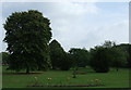
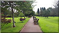
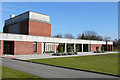
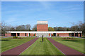
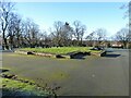
Walkway and lawns, St Helens Crematorium
Image: © Peter Bond
Taken: 31 May 2012
0.10 miles
8
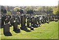
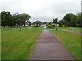
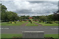
St Helens cemetery
Rows of black marble gravestones line the hillside as it slopes down towards the Rainford Road.
Image: © Chris Denny
Taken: 22 Apr 2010
0.19 miles
9
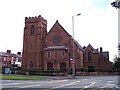
St Thomas Of Canterbury RC church in Dentons Green
Image: © Raymond Knapman
Taken: 12 Aug 2010
0.21 miles
10
Floor plan of mortuary chapel
The remains of the Non-conformist Mortuary Chapel in St Helens Borough Cemetery. The chapel was demolished in 1969.
Image: © Kevin Waterhouse
Taken: 2 Jan 2025
0.22 miles