IMAGES TAKEN NEAR TO
Rainford Road, ST. HELENS, WA10 6BZ
Introduction
This page details the photographs taken nearby to Rainford Road, WA10 6BZ by members of the Geograph project.
The Geograph project started in 2005 with the aim of publishing, organising and preserving representative images for every square kilometre of Great Britain, Ireland and the Isle of Man.

There are currently over 7.5m images from over14,400 individuals and you can help contribute to the project by visiting https://www.geograph.org.uk
Image Map
Images are licensed for reuse under creativecommons.org/licenses/by-sa/2.0
Notes
- Clicking on the map will re-center to the selected point.
- The higher the marker number, the further away the image location is from the centre of the postcode.
Image Listing (19 Images Found)
Images are licensed for reuse under creativecommons.org/licenses/by-sa/2.0
Image
Details
Distance
1
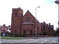
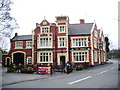
St Thomas Of Canterbury RC church in Dentons Green
Image: © Raymond Knapman
Taken: 12 Aug 2010
0.12 miles
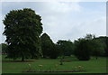
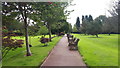
6
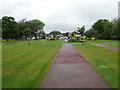
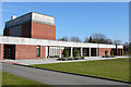
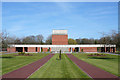
Walkway and lawns, St Helens Crematorium
Image: © Peter Bond
Taken: 31 May 2012
0.19 miles