IMAGES TAKEN NEAR TO
Houghtons Lane, ST. HELENS, WA10 5QF
Introduction
This page details the photographs taken nearby to Houghtons Lane, WA10 5QF by members of the Geograph project.
The Geograph project started in 2005 with the aim of publishing, organising and preserving representative images for every square kilometre of Great Britain, Ireland and the Isle of Man.

There are currently over 7.5m images from over14,400 individuals and you can help contribute to the project by visiting https://www.geograph.org.uk
Image Map
Images are licensed for reuse under creativecommons.org/licenses/by-sa/2.0
Notes
- Clicking on the map will re-center to the selected point.
- The higher the marker number, the further away the image location is from the centre of the postcode.
Image Listing (24 Images Found)
Images are licensed for reuse under creativecommons.org/licenses/by-sa/2.0
Image
Details
Distance
1
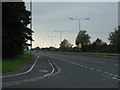
East Lancashire Road (A580)
Heading west at the junction with Houghtons Lane.
Image: © JThomas
Taken: 13 Sep 2014
0.01 miles
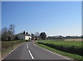
2
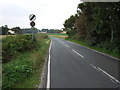
Houghtons Lane
Heading south from the East Lancashire Road (A580).
Image: © JThomas
Taken: 13 Sep 2014
0.04 miles
3

Stubble field beside the East Lancashire Road (A580)
Looking east.
Image: © JThomas
Taken: 13 Sep 2014
0.06 miles
4

Houghtons Lane/E Lancashire Road junction
Image: © Colin Pyle
Taken: 14 Aug 2010
0.06 miles

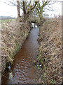
6
Footbridge over Windle Brook, Watery Lane
Image: © Gary Rogers
Taken: 20 Feb 2015
0.12 miles
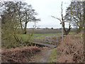
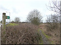
8

Footpath to Watery Lane Farm, Windle from the A580
Image: © Gary Rogers
Taken: 20 Feb 2015
0.14 miles
10
Footpath to Watery Lane Farm, Windle from the A580
Image: © Gary Rogers
Taken: 20 Feb 2015
0.18 miles