IMAGES TAKEN NEAR TO
Houghtons Lane, ST. HELENS, WA10 5QE
Introduction
This page details the photographs taken nearby to Houghtons Lane, WA10 5QE by members of the Geograph project.
The Geograph project started in 2005 with the aim of publishing, organising and preserving representative images for every square kilometre of Great Britain, Ireland and the Isle of Man.

There are currently over 7.5m images from over14,400 individuals and you can help contribute to the project by visiting https://www.geograph.org.uk
Image Map
Images are licensed for reuse under creativecommons.org/licenses/by-sa/2.0
Notes
- Clicking on the map will re-center to the selected point.
- The higher the marker number, the further away the image location is from the centre of the postcode.
Image Listing (15 Images Found)
Images are licensed for reuse under creativecommons.org/licenses/by-sa/2.0
Image
Details
Distance
1
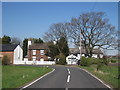
Lower Barrow Field Farm
Lower Barrow Field Farm on Houghton's Lane.
Image: © Sue Adair
Taken: 18 Apr 2015
0.01 miles
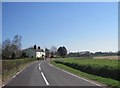
2
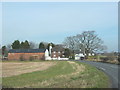
Houghton's Lane towards Lower Barrow Field Farm
Image: © Gary Rogers
Taken: 11 Mar 2016
0.02 miles
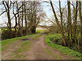
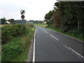
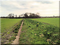
5
A bend in Houghtons Lane
Heading towards Eccleston.
Image: © JThomas
Taken: 13 Sep 2014
0.08 miles
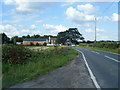
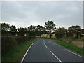
7
Houghtons Lane
Heading south from the East Lancashire Road (A580).
Image: © JThomas
Taken: 13 Sep 2014
0.21 miles
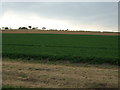
9

Stubble field beside the East Lancashire Road (A580)
Looking east.
Image: © JThomas
Taken: 13 Sep 2014
0.22 miles