IMAGES TAKEN NEAR TO
Brentwood Close, ST. HELENS, WA10 5NR
Introduction
This page details the photographs taken nearby to Brentwood Close, WA10 5NR by members of the Geograph project.
The Geograph project started in 2005 with the aim of publishing, organising and preserving representative images for every square kilometre of Great Britain, Ireland and the Isle of Man.

There are currently over 7.5m images from over14,400 individuals and you can help contribute to the project by visiting https://www.geograph.org.uk
Image Map
Images are licensed for reuse under creativecommons.org/licenses/by-sa/2.0
Notes
- Clicking on the map will re-center to the selected point.
- The higher the marker number, the further away the image location is from the centre of the postcode.
Image Listing (18 Images Found)
Images are licensed for reuse under creativecommons.org/licenses/by-sa/2.0
Image
Details
Distance
1
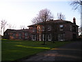
Eccleston Hall
The third Hall to be built on this site,(17th c.) seat of the Eccleston Family before handing over to Taylors in the 18th.century. Lord Eccleston raised an army of Lancashire Archers who routed the French at the Battle of Agincourt in 1415, and at Crecy. Now converted to residential apartments.
Image: © Michael Heavey
Taken: 15 Feb 2007
0.07 miles
2
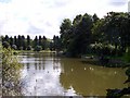
Mill Dam, Millfields, Eccleston
Mill Dam, Millfields, Eccleston which is a private fishing pond for Pilkingtons.
Image: © Sue Adair
Taken: 18 Feb 2006
0.13 miles
3
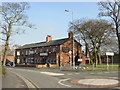
The Griffin Inn, Eccleston
The Griffin Inn, an old coaching inn at the junction of Church Lane with Millfields, Eccleston. The left side of the building dates back to 1620, an inn originally called The Magpie. The Griffin Inn as we see it today came into existence in 1812, taking its name from the crest of the family resident at Eccleston Hall.
Image: © Sue Adair
Taken: 18 Feb 2006
0.13 miles
7
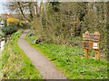
Mill Brow Local Nature Reserve, Eccleston
Mill Wood is one of the few wet broadleaf woodland sites in St Helens. Drainage ditches were dug to enable woodland planting to take place possibly in the early 20th century and in recent years, local residents and volunteers led by Lancashire Wildlife Trust carried out work Mill Wood and Mill Brow to upgrade footpaths and boardwalks, and to improve tree management and rhododendron control working in partnership with St Helens Council and Eccleston Parish Council (https://bit.ly/2WMBhkw ). The area was declared local nature reserve in 2016 (https://bit.ly/2G4hCXV St Helens Council). The improved Mill Brow also provides an outdoor classroom facility for the neighbouring De La Salle School.
Image: © David Dixon
Taken: 31 Mar 2019
0.16 miles
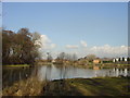
8
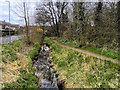
Eccleston, Mill Brook
Mill Brook runs through Eccleston and connects with Windle Brook and the disused St Helens branch of the Sankey Canal in the town centre.
Image: © David Dixon
Taken: 31 Mar 2019
0.16 miles
9
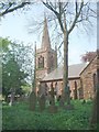
Christ Church Eccleston, St Helens
Eccleston Parish Church was built in 1836 by the local squire Samuel Taylor and his emblem a griffin is the weather vane and gave the name to the nearby Griffin Inn
Image: © John Stead
Taken: 12 May 2006
0.18 miles