IMAGES TAKEN NEAR TO
High Legh, ST. HELENS, WA10 5NA
Introduction
This page details the photographs taken nearby to High Legh, WA10 5NA by members of the Geograph project.
The Geograph project started in 2005 with the aim of publishing, organising and preserving representative images for every square kilometre of Great Britain, Ireland and the Isle of Man.

There are currently over 7.5m images from over14,400 individuals and you can help contribute to the project by visiting https://www.geograph.org.uk
Image Map
Images are licensed for reuse under creativecommons.org/licenses/by-sa/2.0
Notes
- Clicking on the map will re-center to the selected point.
- The higher the marker number, the further away the image location is from the centre of the postcode.
Image Listing (13 Images Found)
Images are licensed for reuse under creativecommons.org/licenses/by-sa/2.0
Image
Details
Distance
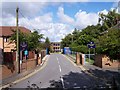
1
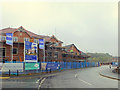
Exclusively Jones, Housing development at Eccleston Grange
Image: © Gary Rogers
Taken: 21 Oct 2015
0.05 miles
2
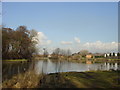
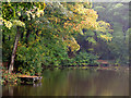
Mill Dam, Millfields, Eccleston
Mill Dam, Millfields, Eccleston which is a private fishing pond for Pilkingtons.
Image: © Sue Adair
Taken: 18 Feb 2006
0.10 miles
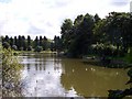
4
Eccleston Top Dam
Eccleston Top Dam at Eccleston, near St Helens, Merseyside
Image: © Lorna Lyons
Taken: 15 Jul 2007
0.13 miles
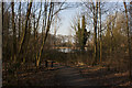
8
Road entrance to De La Salle School, Mill Brow
Image: © Raymond Knapman
Taken: 12 Aug 2010
0.18 miles
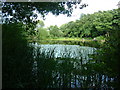
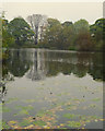
9
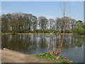
Leg O' Mutton Dam
This area was formerly part of the ancient manorial estate of Eccleston. Samuel Taylor VII gave 47 acres of the estate for use as a public park in 1892 which included 3 areas of water, Big Dam, Eccleston Bottom Dam (now Leg o' Mutton Dam) and Little Dam (now covered over). This small dam is managed by St. Helens fishing Club.
Image: © Sue Adair
Taken: 14 Apr 2007
0.18 miles
10
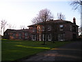
Eccleston Hall
The third Hall to be built on this site,(17th c.) seat of the Eccleston Family before handing over to Taylors in the 18th.century. Lord Eccleston raised an army of Lancashire Archers who routed the French at the Battle of Agincourt in 1415, and at Crecy. Now converted to residential apartments.
Image: © Michael Heavey
Taken: 15 Feb 2007
0.20 miles