IMAGES TAKEN NEAR TO
Bobbies Lane, ST. HELENS, WA10 5BH
Introduction
This page details the photographs taken nearby to Bobbies Lane, WA10 5BH by members of the Geograph project.
The Geograph project started in 2005 with the aim of publishing, organising and preserving representative images for every square kilometre of Great Britain, Ireland and the Isle of Man.

There are currently over 7.5m images from over14,400 individuals and you can help contribute to the project by visiting https://www.geograph.org.uk
Image Map
Images are licensed for reuse under creativecommons.org/licenses/by-sa/2.0
Notes
- Clicking on the map will re-center to the selected point.
- The higher the marker number, the further away the image location is from the centre of the postcode.
Image Listing (11 Images Found)
Images are licensed for reuse under creativecommons.org/licenses/by-sa/2.0
Image
Details
Distance
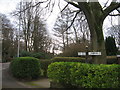
2
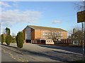
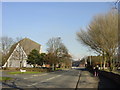
St.Julie's RC. Church, Howards Lane, Eccleston
The Church is opposite to the Carmelite Convent.
Image: © Michael Heavey
Taken: 22 Feb 2007
0.19 miles
3
St.Julie's Roman Catholic Church
On Howards Lane, Eccleston
Image: © JThomas
Taken: 13 Sep 2014
0.21 miles
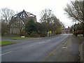
4
Howards Lane, Eccleston
Heading south west.
Image: © JThomas
Taken: 13 Sep 2014
0.21 miles
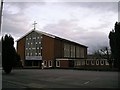
5
Eccleston Methodist Church, Burrows Lane
Eccleston means church farm or settlement. "Eccles" which is found in several place names in the North West of England is derived from the Welsh "Eglwys" and the use of this word implies a Celtic religious foundation. However, Christ Church half a mile to the north on Church Lane was built between 1838/9 and is considerably older than this modern church.
Image: © Sue Adair
Taken: 18 Feb 2006
0.22 miles
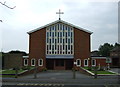
6
Eccleston Methodist Church, sad end for the building.
Quote from Eccleston Parish Council magazine 2005/2006.
“In 1963 Westfield Street Methodist Church in
central St Helens closed for worship and the
building was demolished under a compulsory
purchase order. The trustees had already made
provision for its continuing life by purchasing a
large house with extensive grounds in Burrows
Lane, Eccleston.
The house became a residence for the minister and
the lounge served as a place of worship for nearly
four years until the present church was built and
opened in June 1967 by the late Lady Pilkington.”
The church closed in May 2006 and the land was sold for residential development.
On the night of 5th November 2010 a fire badly damaged the building though its fate was already sealed.
Image: © Roy Prescott
Taken: 21 Nov 2010
0.22 miles
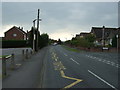
7
Signpost junction of Church Lane and Springfield Lane
Image: © Sue Adair
Taken: 1 Feb 2020
0.23 miles
8
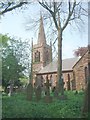
Christ Church Eccleston, St Helens
Eccleston Parish Church was built in 1836 by the local squire Samuel Taylor and his emblem a griffin is the weather vane and gave the name to the nearby Griffin Inn
Image: © John Stead
Taken: 12 May 2006
0.24 miles
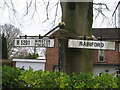
9
Old Signpost Eccleston
Old signpost at the junction of Church Lane, Springfield Lane and Chapel Lane indicating Whiston/Prescot on the B5201 and Rainford. At some time in the past it may have had a third arm to Windle/Wigan.
Image: © Sue Adair
Taken: 1 Feb 2020
0.24 miles
10
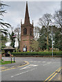
Eccleston, Christ Church
A view of the west end of the church with its three-stage tower topped by a spire.
Image: © David Dixon
Taken: 31 Mar 2019
0.25 miles