IMAGES TAKEN NEAR TO
Seddon Close, ST. HELENS, WA10 5AG
Introduction
This page details the photographs taken nearby to Seddon Close, WA10 5AG by members of the Geograph project.
The Geograph project started in 2005 with the aim of publishing, organising and preserving representative images for every square kilometre of Great Britain, Ireland and the Isle of Man.

There are currently over 7.5m images from over14,400 individuals and you can help contribute to the project by visiting https://www.geograph.org.uk
Image Map
Images are licensed for reuse under creativecommons.org/licenses/by-sa/2.0
Notes
- Clicking on the map will re-center to the selected point.
- The higher the marker number, the further away the image location is from the centre of the postcode.
Image Listing (6 Images Found)
Images are licensed for reuse under creativecommons.org/licenses/by-sa/2.0
Image
Details
Distance
3
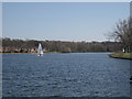
Eccleston Mere
Eccleston Mere is owned by Pilkingtons, originally constructed to hold water for the Watson Street works is now used solely for recreational purposes such as sailing and fishing.
Image: © Sue Adair
Taken: 18 Apr 2015
0.07 miles
4
Eccleston Methodist Church, Burrows Lane
Eccleston means church farm or settlement. "Eccles" which is found in several place names in the North West of England is derived from the Welsh "Eglwys" and the use of this word implies a Celtic religious foundation. However, Christ Church half a mile to the north on Church Lane was built between 1838/9 and is considerably older than this modern church.
Image: © Sue Adair
Taken: 18 Feb 2006
0.19 miles
5
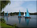
Dinghy Racing on Eccleston Mere
Members of Pilkington Sailing Club racing on Eccleston Mere, St Helens.
Image: © Margaret Rogers
Taken: 21 Sep 2008
0.22 miles
6
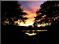
Sunset on Grandad's Bridge, Eccleston Mere
The bridge sits astride one of two overflow outlets, there is also one on the opposite side of the Mere.
Image: © Michael Heavey
Taken: 20 Aug 2006
0.23 miles