IMAGES TAKEN NEAR TO
Morrissey Close, ST. HELENS, WA10 4JW
Introduction
This page details the photographs taken nearby to Morrissey Close, WA10 4JW by members of the Geograph project.
The Geograph project started in 2005 with the aim of publishing, organising and preserving representative images for every square kilometre of Great Britain, Ireland and the Isle of Man.

There are currently over 7.5m images from over14,400 individuals and you can help contribute to the project by visiting https://www.geograph.org.uk
Image Map
Images are licensed for reuse under creativecommons.org/licenses/by-sa/2.0
Notes
- Clicking on the map will re-center to the selected point.
- The higher the marker number, the further away the image location is from the centre of the postcode.
Image Listing (10 Images Found)
Images are licensed for reuse under creativecommons.org/licenses/by-sa/2.0
Image
Details
Distance
2
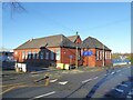
Queen's Park Primary School
On Rivington Road. The road is built along the line of the Rivington Aqueduct taking water to Liverpool.
Image: © Kevin Waterhouse
Taken: 2 Jan 2025
0.18 miles
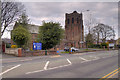
4
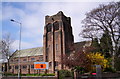
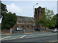
St Luke's, Eccleston
1931. Architects Byram & Fletcher.
Image: © S Parish
Taken: 5 Apr 2007
0.19 miles
7
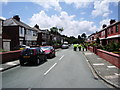
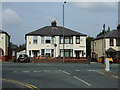
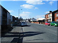
Coleridge Avenue, St Helens
There's a lot of yellow jackets down there I wonder what are they doing?
Image: © Alexander P Kapp
Taken: 2 Jul 2007
0.22 miles
9
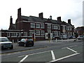
The Black Bull
Large public house on Knowsley Road, St Helens.
Image: © David Dixon
Taken: 31 Mar 2019
0.22 miles